Randonnée Marche Saint-Aventin - Pic de Céciré - Photo
 reneperrin
reneperrin

Utilisateur

© OpenStreetMap contributors
Longueur
Longueur
12,8 km
Altitude max
Altitude max
2384 m
Dénivelé positif
Dénivelé positif
673 m
Km-Effort
Km-Effort  
22 km
Altitude min
Altitude min
1775 m
Dénivelé négatif
Dénivelé négatif
672 m
Boucle
Boucle
Oui
Date de création :
2014-12-10 00:00:00.0
Dernière modification :
2014-12-10 00:00:00.0

(0 Avis)

Marche
Marche
4h02
Difficulté : Moyen

Scannez ce code QR pour ouvrir la randonnée dans l'application SityTrail

Application GPS de randonnée GRATUITE

Logo SityTrail SityTrail

IGN / Instituts géographiques

Télécharger SityTrail sur l'App Store Télécharger SityTrail sur Google Play

Logo SityTrail SityTrail World

Le monde est à vous

Télécharger SityTrail sur l'App Store Télécharger SityTrail sur Google Play Télécharger SityTrail sur Huawei AppGallery

À propos

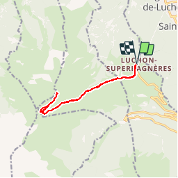
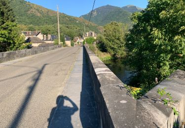
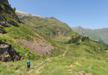
Randonnée Marche de 12,8 km à découvrir à Occitanie, Haute-Garonne, Saint-Aventin. Cette randonnée est proposée par reneperrin.

Description

Départ de Super Bagnères par le GR10 jusqu'au col puis traversée pour rejoindre la voie normale et l'arrête

Profil altimétrique

Photos

Localisation

Pays :
France
Région :
Occitanie
Département/Province :
Haute-Garonne
Commune :
Saint-Aventin
Localité :
Unknown
Départ:(Dec)
Départ:(UTM)
301766 ; 4737931 (31T) N.

Randonnées à proximité

Randonnée Raquettes à neige Juzet-de-Luchon - JUZET - PAS DE LA COMBE (LABACH) - Photo
Raquettes à neige
Marcocroco

Raquettes à neige

Moyen
(1)
Juzet-de-Luchon, Occitanie, Haute-Garonne, France
7,1 km | 12,5 km-effort
2h 33min
Oui
Randonnée Marche Saint-Mamet - Fonds de Burbe - Saint Mamet - Photo
Marche
tracegps

Marche

Difficile
(1)
Saint-Mamet, Occitanie, Haute-Garonne, France
15,6 km | 27 km-effort
4h 0min
Oui
Randonnée V.T.T. Saint-Aventin - Luchon Kbour - Photo
V.T.T.
tracegps

V.T.T.

Très difficile
(1)
Saint-Aventin, Occitanie, Haute-Garonne, France
11 km | 16,7 km-effort
1h 0min
Non
Randonnée A pied Castillon-de-Larboust - Lac Vert, Boucle par l'Est - Photo
A pied
PRO

A pied

Facile
Castillon-de-Larboust, Occitanie, Haute-Garonne, France
8,8 km | 19,5 km-effort
4h 26min
Non
Randonnée Marche Bagnères-de-Luchon - GR 10 - 3 - Photo
Marche
loic09

Marche

Moyen
(2)
Bagnères-de-Luchon, Occitanie, Haute-Garonne, France
250 km | 489 km-effort
89h 8min
Non
Randonnée Marche Saint-Aventin - Cabane de Courreau en boucle depuis St Aventin  - Photo
Marche
GUIDE
lhomme.ph

Marche

Moyen
Saint-Aventin, Occitanie, Haute-Garonne, France
13,3 km | 24 km-effort
6h 10min
Oui
Randonnée Marche Castillon-de-Larboust - Cabane de la Coume - Photo
Marche
swp648

Marche

Difficile
Castillon-de-Larboust, Occitanie, Haute-Garonne, France
9,1 km | 18,4 km-effort
3h 39min
Oui
Randonnée Marche Bagnères-de-Luchon - 2022 08 -Transpyrénéen 2 : Bagnères de Luchon -Fos - Photo
Marche
LEGUE

Marche

Très difficile
Bagnères-de-Luchon, Occitanie, Haute-Garonne, France
30 km | 55 km-effort
7h 8min
Non
Randonnée Marche Castillon-de-Larboust - lacs vert et bleu en boucle - Photo
Marche
chrisgps

Marche

Difficile
Castillon-de-Larboust, Occitanie, Haute-Garonne, France
15,2 km | 32 km-effort
9h 17min
Oui


Fermer
Mes abonnements