


RD-Plan-Les étangs

raymondfn
Utilisateur
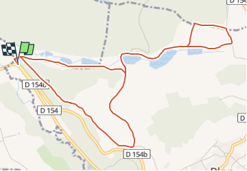

Longueur
6,6 km

Altitude max
559 m

Dénivelé positif
146 m
Km-Effort
8,6 km

Altitude min
457 m

Dénivelé négatif
147 m
Boucle
Oui
Date de création :
2022-07-15 14:00:49.017
Dernière modification :
2022-07-15 14:08:28.944
1h58
Difficulté : Facile

Application GPS de randonnée GRATUITE
 SityTrail
IGN / Instituts géographiques
SityTrail Plus
Le monde est à vous
À propos
Randonnée A pied de 6,6 km à découvrir à Auvergne-Rhône-Alpes, Isère, Plan. Cette randonnée est proposée par raymondfn.
Localisation
Pays :
France
Région :
Auvergne-Rhône-Alpes
Département/Province :
Isère
Commune :
Plan
Localité :
Unknown
Départ:(Dec)
Départ:(UTM)
685509 ; 5021475 (31T) N.
Commentaires