


VALLON DU BRUYANT - BEC DE L'AIGLE

jpb83
Utilisateur
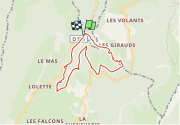

Longueur
7,3 km

Altitude max
1138 m

Dénivelé positif
297 m
Km-Effort
11,3 km

Altitude min
912 m

Dénivelé négatif
295 m
Boucle
Oui
Date de création :
2022-07-19 14:06:23.727
Dernière modification :
2022-07-19 14:06:25.658
2h33
Difficulté : Facile

Application GPS de randonnée GRATUITE
 SityTrail
IGN / Instituts géographiques
SityTrail Plus
Le monde est à vous
À propos
Randonnée Marche de 7,3 km à découvrir à Auvergne-Rhône-Alpes, Isère, Lans-en-Vercors. Cette randonnée est proposée par jpb83.
Localisation
Pays :
France
Région :
Auvergne-Rhône-Alpes
Département/Province :
Isère
Commune :
Lans-en-Vercors
Localité :
Unknown
Départ:(Dec)
Départ:(UTM)
704755 ; 5003272 (31T) N.
Commentaires