


romain

danif
Utilisateur
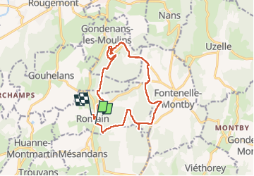

Longueur
14,4 km

Altitude max
476 m

Dénivelé positif
379 m
Km-Effort
19,5 km

Altitude min
311 m

Dénivelé négatif
401 m
Boucle
Non
Date de création :
2022-07-21 07:10:44.097
Dernière modification :
2022-07-21 13:35:51.012
4h15
Difficulté : Très difficile

Application GPS de randonnée GRATUITE
 SityTrail
IGN / Instituts géographiques
SityTrail Plus
Le monde est à vous
À propos
Randonnée Marche de 14,4 km à découvrir à Bourgogne-Franche-Comté, Doubs, Romain. Cette randonnée est proposée par danif.
Localisation
Pays :
France
Région :
Bourgogne-Franche-Comté
Département/Province :
Doubs
Commune :
Romain
Localité :
Unknown
Départ:(Dec)
Départ:(UTM)
302138 ; 5257409 (32T) N.
Commentaires