


TL 08/22Werschmatt - Col d'Oderen - Chemin des Alliés Abri Langenbach et retour

patrickbeyrath
Utilisateur
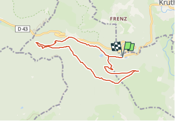

Longueur
8,1 km

Altitude max
928 m

Dénivelé positif
325 m
Km-Effort
12,5 km

Altitude min
619 m

Dénivelé négatif
324 m
Boucle
Oui
Date de création :
2022-08-10 09:38:05.298
Dernière modification :
2022-08-13 05:37:49.601
3h22
Difficulté : Moyen

Application GPS de randonnée GRATUITE
 SityTrail
IGN / Instituts géographiques
SityTrail Plus
Le monde est à vous
À propos
Randonnée Marche de 8,1 km à découvrir à Grand Est, Haut-Rhin, Oderen. Cette randonnée est proposée par patrickbeyrath.
Localisation
Pays :
France
Région :
Grand Est
Département/Province :
Haut-Rhin
Commune :
Oderen
Localité :
Unknown
Départ:(Dec)
Départ:(UTM)
346732 ; 5309159 (32T) N.
Commentaires
Attention. Le tour est actuellement impossible le 13/04/2024 pour travaux forestier. Magnifique randonnée en sous bois.