


Mittaghorn par via ferrata

mpignon
Utilisateur
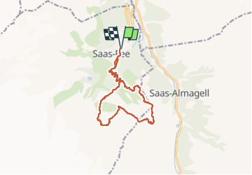

Longueur
14,6 km

Altitude max
3121 m

Dénivelé positif
1377 m
Km-Effort
33 km

Altitude min
1772 m

Dénivelé négatif
1377 m
Boucle
Oui
Date de création :
2022-08-14 05:19:36.524
Dernière modification :
2022-08-17 10:22:22.119
7h14
Difficulté : Moyen

Application GPS de randonnée GRATUITE
 SityTrail
IGN / Instituts géographiques
SityTrail Plus
Le monde est à vous
À propos
Randonnée Via ferrata de 14,6 km à découvrir à Valais, Viège, Saas-Fee. Cette randonnée est proposée par mpignon.
Localisation
Pays :
Suisse
Région :
Valais
Département/Province :
Viège
Commune :
Saas-Fee
Localité :
Unknown
Départ:(Dec)
Départ:(UTM)
417272 ; 5106681 (32T) N.
Commentaires