


VTT 27 Aout 2014

norbertmarteau
Utilisateur
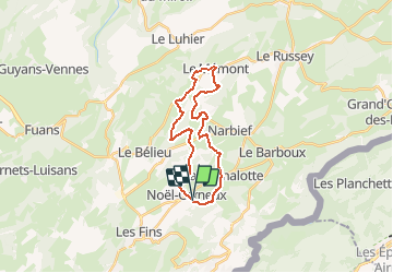

Longueur
22 km

Altitude max
1066 m

Dénivelé positif
560 m
Km-Effort
30 km

Altitude min
883 m

Dénivelé négatif
557 m
Boucle
Oui
Date de création :
2014-12-10 00:00:00.0
Dernière modification :
2014-12-10 00:00:00.0
1h53
Difficulté : Facile

Application GPS de randonnée GRATUITE
 SityTrail
IGN / Instituts géographiques
SityTrail Plus
Le monde est à vous
À propos
Randonnée V.T.T. de 22 km à découvrir à Bourgogne-Franche-Comté, Doubs, Noël-Cerneux. Cette randonnée est proposée par norbertmarteau.
Localisation
Pays :
France
Région :
Bourgogne-Franche-Comté
Département/Province :
Doubs
Commune :
Noël-Cerneux
Localité :
Unknown
Départ:(Dec)
Départ:(UTM)
322919 ; 5218866 (32T) N.
Commentaires