Randonnée V.T.T. Andolsheim - VTT 15/11/22 effectuée  - Photo

VTT 15/11/22 effectuée

 ABICHE
ABICHE

Utilisateur

© OpenStreetMap contributors
Longueur
Longueur
11,6 km
Altitude max
Altitude max
197 m
Dénivelé positif
Dénivelé positif
62 m
Km-Effort
Km-Effort  
12,5 km
Altitude min
Altitude min
183 m
Dénivelé négatif
Dénivelé négatif
70 m
Boucle
Boucle
Non
Date de création :
2022-11-15 09:29:27.321
Dernière modification :
2023-02-22 12:39:19.392

(1 Avis)

V.T.T.
V.T.T.
1h26
Difficulté : Facile

Scannez ce code QR pour ouvrir la randonnée dans l'application SityTrail

Application GPS de randonnée GRATUITE

Logo SityTrail SityTrail

IGN / Instituts géographiques

Télécharger SityTrail sur l'App Store Télécharger SityTrail sur Google Play

Logo SityTrail SityTrail World

Le monde est à vous

Télécharger SityTrail sur l'App Store Télécharger SityTrail sur Google Play Télécharger SityTrail sur Huawei AppGallery

À propos

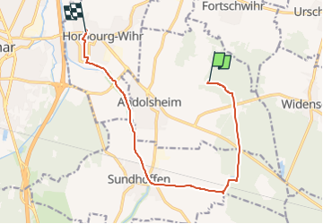
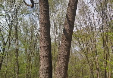
Randonnée V.T.T. de 11,6 km à découvrir à Grand Est, Haut-Rhin, Andolsheim. Cette randonnée est proposée par ABICHE.

Profil altimétrique

Localisation

Pays :
France
Région :
Grand Est
Département/Province :
Haut-Rhin
Commune :
Andolsheim
Localité :
Unknown
Départ:(Dec)
Départ:(UTM)
383882 ; 5325128 (32U) N.

Commentaires

Veuillez vous connecter pour laisser un commentaire ou une note


Randonnées à proximité

Randonnée Marche Colmar - Colmar petite Venise  - Photo
Marche
FOUCAULT

Marche

Colmar, Grand Est, Haut-Rhin, France
9,3 km | 10,1 km-effort
3h 16min
Oui
Randonnée Course à pied Widensolen - Widensolen, un tracé 100% plaisir  - Photo
Course à pied
zazie

Course à pied

Très facile
Widensolen, Grand Est, Haut-Rhin, France
12,1 km | 12,9 km-effort
1h 1min
Oui
Randonnée Course à pied Colmar - Boucle Dachsbulh Colmar Course  - Photo
Course à pied
zazie

Course à pied

Très facile
Colmar, Grand Est, Haut-Rhin, France
11 km | 12,1 km-effort
1h 1min
Oui
Randonnée Marche Wolfgantzen - Markstein - Moorfeld - Photo
Marche
jmbilger

Marche

Très facile
Wolfgantzen, Grand Est, Haut-Rhin, France
43 km | 67 km-effort
2h 15min
Non
Randonnée Marche Colmar - COLMAR - FORÊT DU NEULAND - Photo
Marche
jean-marie.parachini

Marche

Très facile
Colmar, Grand Est, Haut-Rhin, France
5,2 km | 6 km-effort
1h 17min
Oui
Randonnée Course à pied Colmar - Run du matin en forêt de Neuland - Colmar - Photo
Course à pied
tracegps

Course à pied

Facile
Colmar, Grand Est, Haut-Rhin, France
6,8 km | 7,6 km-effort
45min
Oui
Randonnée V.T.T. Widensolen - Vélo avec pet  - Photo
V.T.T.
juliengsell

V.T.T.

Facile
Widensolen, Grand Est, Haut-Rhin, France
10,1 km | 10,8 km-effort
1h 4min
Oui
Randonnée V.T.C. Widensolen - Sortie vélo glaces de l ill  - Photo
V.T.C.
juliengsell

V.T.C.

Facile
Widensolen, Grand Est, Haut-Rhin, France
18,8 km | 20 km-effort
1h 46min
Non
Randonnée Marche Widensolen - Randonnée Forêt et plaine de Widensolen  - Photo
Marche
zazie

Marche

Très facile
Widensolen, Grand Est, Haut-Rhin, France
9,2 km | 9,8 km-effort
1h 42min
Oui


Fermer
Mes abonnements