Randonnée Marche Vandœuvre-lès-Nancy - Vandoeuvre-lès-Nancy 18 070m +375m - Photo

Vandoeuvre-lès-Nancy 18 070m +375m

 DanielROLLET
DanielROLLET

Utilisateur

© OpenStreetMap contributors
Longueur
Longueur
18,1 km
Altitude max
Altitude max
402 m
Dénivelé positif
Dénivelé positif
376 m
Km-Effort
Km-Effort  
23 km
Altitude min
Altitude min
242 m
Dénivelé négatif
Dénivelé négatif
382 m
Boucle
Boucle
Oui
Date de création :
2022-11-18 07:58:37.974
Dernière modification :
2022-11-18 19:28:20.421

(0 Avis)

Marche
Marche
4h40
Difficulté : Moyen

Scannez ce code QR pour ouvrir la randonnée dans l'application SityTrail

Application GPS de randonnée GRATUITE

Logo SityTrail SityTrail

IGN / Instituts géographiques

Télécharger SityTrail sur l'App Store Télécharger SityTrail sur Google Play

Logo SityTrail SityTrail World

Le monde est à vous

Télécharger SityTrail sur l'App Store Télécharger SityTrail sur Google Play Télécharger SityTrail sur Huawei AppGallery

À propos

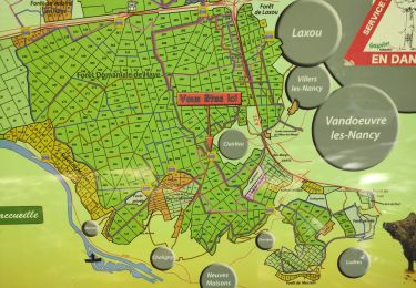
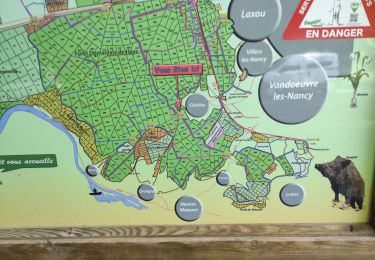
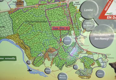
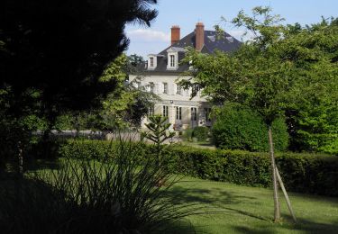
Randonnée Marche de 18,1 km à découvrir à Grand Est, Meurthe-et-Moselle, Vandœuvre-lès-Nancy. Cette randonnée est proposée par DanielROLLET.

Description

2022 11 18 - 9h00 à 12h50   14h10 à 15h00 - Temps frais et variable
Départ/arrivée chapelle N.D. des Pauvres
Halte au resto "Le Singe Hardi" 12h50 à 14h00

Profil altimétrique

Localisation

Pays :
France
Région :
Grand Est
Département/Province :
Meurthe-et-Moselle
Commune :
Vandœuvre-lès-Nancy
Localité :
Unknown
Départ:(UTM)
290581 ; 5393219 (32U) N.

Randonnées à proximité

Randonnée A pied Fléville-devant-Nancy - Fléville-devant-Nancy et son château - Photo
A pied
PRO

A pied

Facile
Fléville-devant-Nancy, Grand Est, Meurthe-et-Moselle, France
7,9 km | 9,4 km-effort
2h 8min
Oui
Randonnée Marche Nancy - Ma dernière avant opération  - Photo
Marche
Toyot 8

Marche

Très difficile
(1)
Nancy, Grand Est, Meurthe-et-Moselle, France
22 km | 25 km-effort
4h 12min
Oui
Randonnée Marche Vandœuvre-lès-Nancy - Randonnée USEP 2023 - Photo
Marche
nicolas54230

Marche

Difficile
(1)
Vandœuvre-lès-Nancy, Grand Est, Meurthe-et-Moselle, France
11,7 km | 15,2 km-effort
3h 27min
Non
Randonnée Marche Ludres - marche nuit - Photo
Marche
JJG54

Marche

Moyen
Ludres, Grand Est, Meurthe-et-Moselle, France
8,7 km | 10,1 km-effort
2h 11min
Oui
Randonnée Marche Nancy - Ma rando du jour - Photo
Marche
Toyot 8

Marche

Difficile
Nancy, Grand Est, Meurthe-et-Moselle, France
35 km | 41 km-effort
5h 55min
Oui
Randonnée Marche Nancy - Nancy Gondreville Nancy - Photo
Marche
Toyot 8

Marche

Difficile
Nancy, Grand Est, Meurthe-et-Moselle, France
64 km | 74 km-effort
10h 57min
Oui
Randonnée Marche Nancy - Nancy Saizeray Jaillon Pierre la Treiche Marion Nancy  - Photo
Marche
Toyot 8

Marche

Difficile
Nancy, Grand Est, Meurthe-et-Moselle, France
73 km | 85 km-effort
12h 13min
Oui
Randonnée Marche Villers-lès-Nancy - RANDO DUO AVEC ALEXIS - Photo
Marche
Toyot 8

Marche

Difficile
(1)
Villers-lès-Nancy, Grand Est, Meurthe-et-Moselle, France
38 km | 45 km-effort
10h 19min
Non
Randonnée A pied Villers-lès-Nancy - Promenade d'Hardeval - Photo
A pied
PRO

A pied

Facile
Villers-lès-Nancy, Grand Est, Meurthe-et-Moselle, France
3,2 km | 4,3 km-effort
58min
Oui


Fermer
Mes abonnements