Randonnée Camping-car Virton - Mesurage 9716 - Photo
 Maxime Léonard
Maxime Léonard

Utilisateur

© OpenStreetMap contributors
Longueur
Longueur
146 km
Altitude max
Altitude max
368 m
Dénivelé positif
Dénivelé positif
1726 m
Km-Effort
Km-Effort  
169 km
Altitude min
Altitude min
197 m
Dénivelé négatif
Dénivelé négatif
1725 m
Boucle
Boucle
Oui
Date de création :
2022-11-30 04:07:29.923
Dernière modification :
2022-11-30 08:02:35.501

(0 Avis)

Camping-car
Camping-car
3h54
Difficulté : Très facile

Scannez ce code QR pour ouvrir la randonnée dans l'application SityTrail

Application GPS de randonnée GRATUITE

Logo SityTrail SityTrail

IGN / Instituts géographiques

Télécharger SityTrail sur l'App Store Télécharger SityTrail sur Google Play

Logo SityTrail SityTrail World

Le monde est à vous

Télécharger SityTrail sur l'App Store Télécharger SityTrail sur Google Play Télécharger SityTrail sur Huawei AppGallery

À propos

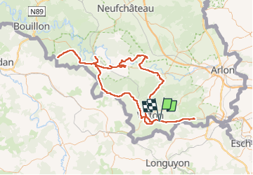
Randonnée Camping-car de 146 km à découvrir à Wallonie, Luxembourg, Virton. Cette randonnée est proposée par Maxime Léonard.

Profil altimétrique

Photos

28 photos au total. Cliquez sur une photo pour les afficher toutes dans la galerie.

Localisation

Pays :
Belgique
Région :
Wallonie
Département/Province :
Luxembourg
Commune :
Virton
Localité :
Unknown
Départ:(UTM)
685823 ; 5492159 (31U) N.

Randonnées à proximité

Randonnée Marche Virton - RB-Lu-17_Ethe_via-var-1-et-2-et-3 - Photo
Marche
PRO

Marche

Très facile
(3)
Virton, Wallonie, Luxembourg, Belgique
29 km | 35 km-effort
7h 33min
Oui
Randonnée V.T.T. Virton - Autour de Ethe  -  Balade_VTT_20kms - Photo
V.T.T.
Pascal L

V.T.T.

Facile
(1)
Virton, Wallonie, Luxembourg, Belgique
21 km | 26 km-effort
1h 40min
Oui
Randonnée Marche Virton - GAUME Balade  naturelle et historique - Photo
Marche
julucasi

Marche

Très facile
(1)
Virton, Wallonie, Luxembourg, Belgique
5,2 km | 6,8 km-effort
1h 16min
Oui
Randonnée A pied Virton - La Bajocienne - Photo
A pied
GUIDE+

A pied

Facile
(1)
Virton, Wallonie, Luxembourg, Belgique
11 km | 14,5 km-effort
3h 17min
Oui
Randonnée A pied Virton - Chenois-Latour Boucle agricole et touristique - Entre villages, pommes et petits fruits - Photo
A pied
GUIDE
DUPONT Rita

A pied

Facile
Virton, Wallonie, Luxembourg, Belgique
6,4 km | 7,7 km-effort
1h 45min
Oui
Randonnée Marche Virton - RB-Lu-17_Ethe_via-racc - Photo
Marche
PRO

Marche

Très facile
Virton, Wallonie, Luxembourg, Belgique
15,6 km | 19,3 km-effort
4h 8min
Oui
Randonnée Marche Virton - RB-Lu-17_Ethe - Photo
Marche
PRO

Marche

Très facile
Virton, Wallonie, Luxembourg, Belgique
22 km | 28 km-effort
5h 55min
Oui
Randonnée V.T.T. Virton - Autour de Tintigny  -  Balade_VTT_54Kms - Photo
V.T.T.
Pascal L

V.T.T.

Très difficile
Virton, Wallonie, Luxembourg, Belgique
54 km | 64 km-effort
4h 25min
Oui
Randonnée V.T.T. Virton - Monquintin  -  Balade_VTT_22Kms - Photo
V.T.T.
Pascal L

V.T.T.

Moyen
Virton, Wallonie, Luxembourg, Belgique
22 km | 26 km-effort
1h 48min
Oui


Fermer
Mes abonnements