Randonnée Marche Sigy-le-Châtel - Sigy Le Chatel - Photo
 Bonnefois Bernard
Bonnefois Bernard

Utilisateur

© OpenStreetMap contributors
Longueur
Longueur
10,7 km
Altitude max
Altitude max
409 m
Dénivelé positif
Dénivelé positif
248 m
Km-Effort
Km-Effort  
14 km
Altitude min
Altitude min
217 m
Dénivelé négatif
Dénivelé négatif
260 m
Boucle
Boucle
Oui
Date de création :
2023-01-13 20:21:56.255
Dernière modification :
2023-03-07 17:37:45.528

(1 Avis)

Marche
Marche
3h11
Difficulté : Facile

Scannez ce code QR pour ouvrir la randonnée dans l'application SityTrail

Application GPS de randonnée GRATUITE

Logo SityTrail SityTrail

IGN / Instituts géographiques

Télécharger SityTrail sur l'App Store Télécharger SityTrail sur Google Play

Logo SityTrail SityTrail World

Le monde est à vous

Télécharger SityTrail sur l'App Store Télécharger SityTrail sur Google Play Télécharger SityTrail sur Huawei AppGallery

À propos

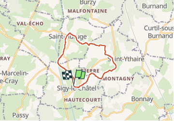
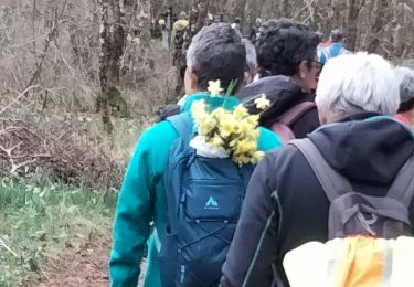
Randonnée Marche de 10,7 km à découvrir à Bourgogne-Franche-Comté, Saône-et-Loire, Sigy-le-Châtel. Cette randonnée est proposée par Bonnefois Bernard.

Description

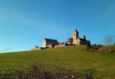
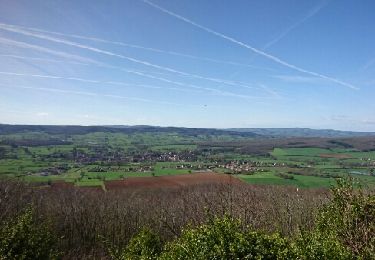
Randonnée de 1km permettant de visiter les villages et châteaux de Sigy le Chatel et Saint-Huruge avec dr jolies vues sur la vallée de la Guye et depuis le belvédère de Chassignol

Profil altimétrique

Localisation

Pays :
France
Région :
Bourgogne-Franche-Comté
Département/Province :
Saône-et-Loire
Commune :
Sigy-le-Châtel
Localité :
Unknown
Départ:(Dec)
Départ:(UTM)
620550 ; 5157022 (31T) N.

Commentaires

Veuillez vous connecter pour laisser un commentaire ou une note


très belle randonnée,mais pas du tout difficile comme indiqué


Randonnées à proximité

Randonnée Marche Saint-Ythaire - Saint Ythaire  Les Jonquilles page 104 - Photo
Marche
grasgilbert

Marche

Moyen
(5)
Saint-Ythaire, Bourgogne-Franche-Comté, Saône-et-Loire, France
12,3 km | 17,2 km-effort
3h 36min
Oui
Randonnée Marche Saint-Ythaire - 2023-03-08_saint-ythaire--les-jonquilles - Photo
Marche
jcbossant

Marche

Difficile
(1)
Saint-Ythaire, Bourgogne-Franche-Comté, Saône-et-Loire, France
12,3 km | 17,2 km-effort
3h 54min
Oui
Randonnée V.T.T. Bonnay - Besanceuil  - Photo
V.T.T.
darrisa

V.T.T.

Moyen
(1)
Bonnay, Bourgogne-Franche-Comté, Saône-et-Loire, France
11,2 km | 15,7 km-effort
3h 52min
Oui
Randonnée Marche Saint-Huruge - Mamou cross the hill - Photo
Marche
margotjl

Marche

Facile
Saint-Huruge, Bourgogne-Franche-Comté, Saône-et-Loire, France
6,1 km | 7,5 km-effort
1h 52min
Oui
Randonnée Marche Saint-Ythaire - oh! les beaux village - Photo
Marche
margotjl

Marche

Moyen
Saint-Ythaire, Bourgogne-Franche-Comté, Saône-et-Loire, France
8,4 km | 11,7 km-effort
2h 28min
Oui
Randonnée Marche Salornay-sur-Guye - 20190822 Salornay sur Guye G3 GC - Photo
Marche
sami55

Marche

Facile
(1)
Salornay-sur-Guye, Bourgogne-Franche-Comté, Saône-et-Loire, France
10,2 km | 14,2 km-effort
3h 2min
Oui
Randonnée Marche Saint-Ythaire - ythair - Photo
Marche
charlolga

Marche

Moyen
Saint-Ythaire, Bourgogne-Franche-Comté, Saône-et-Loire, France
13,8 km | 19,5 km-effort
3h 21min
Oui
Randonnée Marche Sigy-le-Châtel - si gt jonquilles  - Photo
Marche
clozelmarie

Marche

Moyen
(2)
Sigy-le-Châtel, Bourgogne-Franche-Comté, Saône-et-Loire, France
8,4 km | 12 km-effort
3h 15min
Oui
Randonnée Marche Salornay-sur-Guye - circuit salornay sentier du bois de la roche - Photo
Marche
jbsky71

Marche

Facile
Salornay-sur-Guye, Bourgogne-Franche-Comté, Saône-et-Loire, France
8,6 km | 11,8 km-effort
2h 8min
Oui


Fermer
Mes abonnements