


SERRE COCU

nordan
Utilisateur
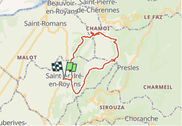

Longueur
13 km

Altitude max
1002 m

Dénivelé positif
694 m
Km-Effort
22 km

Altitude min
374 m

Dénivelé négatif
693 m
Boucle
Oui
Date de création :
2023-01-12 09:04:07.643
Dernière modification :
2023-01-19 06:53:41.944
5h30
Difficulté : Moyen

Application GPS de randonnée GRATUITE
 SityTrail
IGN / Instituts géographiques
SityTrail Plus
Le monde est à vous
À propos
Randonnée Marche de 13 km à découvrir à Auvergne-Rhône-Alpes, Isère, Saint-André-en-Royans. Cette randonnée est proposée par nordan.
Localisation
Pays :
France
Région :
Auvergne-Rhône-Alpes
Département/Province :
Isère
Commune :
Saint-André-en-Royans
Localité :
Unknown
Départ:(Dec)
Départ:(UTM)
684119 ; 4995199 (31T) N.
Commentaires