Randonnée Marche Bévenais - téléthon Bévenais - Photo
 lilloue
lilloue

Utilisateur

© OpenStreetMap contributors
Longueur
Longueur
12 km
Altitude max
Altitude max
718 m
Dénivelé positif
Dénivelé positif
423 m
Km-Effort
Km-Effort  
17,6 km
Altitude min
Altitude min
463 m
Dénivelé négatif
Dénivelé négatif
427 m
Boucle
Boucle
Oui
Date de création :
2023-01-21 07:45:51.638
Dernière modification :
2023-01-21 11:56:20.186

(1 Avis)

Marche
Marche
4h09
Difficulté : Difficile

Scannez ce code QR pour ouvrir la randonnée dans l'application SityTrail

Application GPS de randonnée GRATUITE

Logo SityTrail SityTrail

IGN / Instituts géographiques

Télécharger SityTrail sur l'App Store Télécharger SityTrail sur Google Play

Logo SityTrail SityTrail World

Le monde est à vous

Télécharger SityTrail sur l'App Store Télécharger SityTrail sur Google Play Télécharger SityTrail sur Huawei AppGallery

À propos

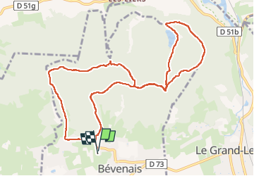
Randonnée Marche de 12 km à découvrir à Auvergne-Rhône-Alpes, Isère, Bévenais. Cette randonnée est proposée par lilloue.

Description

rando

Profil altimétrique

Localisation

Pays :
France
Région :
Auvergne-Rhône-Alpes
Département/Province :
Isère
Commune :
Bévenais
Localité :
Unknown
Départ:(UTM)
686726 ; 5029990 (31T) N.

Commentaires

Veuillez vous connecter pour laisser un commentaire ou une note


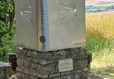
très belle randonnée, bien organisée avec visite chapelle et étang sur parcours. une première pour le téléthon de Bévenais. a refaire l'année prochaine.


Randonnées à proximité

Randonnée Marche Saint-Hilaire-de-la-Côte - RS-Côteau des épées - Photo
Marche
raymondfn

Marche

Facile
(1)
Saint-Hilaire-de-la-Côte, Auvergne-Rhône-Alpes, Isère, France
4,5 km | 5,1 km-effort
1h 9min
Oui
Randonnée Marche Longechenal - Bellindron - Photo
Marche
raymondfn

Marche

Facile
(1)
Longechenal, Auvergne-Rhône-Alpes, Isère, France
10,7 km | 13,9 km-effort
3h 0min
Oui
Randonnée Marche Saint-Hilaire-de-la-Côte - Bocsozel sentier medieval - Photo
Marche
Ninie38MD

Marche

Moyen
Saint-Hilaire-de-la-Côte, Auvergne-Rhône-Alpes, Isère, France
13,1 km | 18,6 km-effort
6h 17min
Oui
Randonnée Marche Bévenais - RD-Le-Grand-Lemps-Bevenais - Photo
Marche
raymondfn

Marche

Moyen
(1)
Bévenais, Auvergne-Rhône-Alpes, Isère, France
8,6 km | 10,4 km-effort
2h 22min
Oui
Randonnée Marche Saint-Hilaire-de-la-Côte - RS-St-Hillaire-de-la-Côte-Fournache - Photo
Marche
raymondfn

Marche

Moyen
(1)
Saint-Hilaire-de-la-Côte, Auvergne-Rhône-Alpes, Isère, France
5,2 km | 6,1 km-effort
1h 23min
Oui
Randonnée Marche Longechenal - lonchenal  - Photo
Marche
jeanpaulgrillon

Marche

Très facile
Longechenal, Auvergne-Rhône-Alpes, Isère, France
8,1 km | 11,1 km-effort
2h 47min
Non
Randonnée Marche La Frette - Le Marais et le Château de La Frette - Photo
Marche
raymondfn

Marche

Moyen
(1)
La Frette, Auvergne-Rhône-Alpes, Isère, France
8,1 km | 9,6 km-effort
2h 5min
Oui
Randonnée Moteur Châbons - Châbons-Bourgoin-Offroad - Photo
Moteur
htonin

Moteur

Moyen
(1)
Châbons, Auvergne-Rhône-Alpes, Isère, France
38 km | 47 km-effort
1h 30min
Non
Randonnée Marche Longechenal - longechenal 2 - Photo
Marche
jeanpaulgrillon

Marche

Facile
Longechenal, Auvergne-Rhône-Alpes, Isère, France
9,7 km | 12,8 km-effort
2h 25min
Oui


Fermer
Mes abonnements