Randonnée Randonnée équestre Belleherbe - GTJ_E02 Sur la Baume > Reculotte - Photo

GTJ_E02 Sur la Baume > Reculotte

 aeldin
aeldin

Utilisateur

© OpenStreetMap contributors
Longueur
Longueur
34 km
Altitude max
Altitude max
873 m
Dénivelé positif
Dénivelé positif
1236 m
Km-Effort
Km-Effort  
49 km
Altitude min
Altitude min
437 m
Dénivelé négatif
Dénivelé négatif
1070 m
Boucle
Boucle
Non
Date de création :
2023-02-06 18:00:23.464
Dernière modification :
2023-05-12 08:40:05.037

(0 Avis)

Randonnée équestre
Randonnée équestre
6h30
Difficulté : Très difficile

Scannez ce code QR pour ouvrir la randonnée dans l'application SityTrail

Application GPS de randonnée GRATUITE

Logo SityTrail SityTrail

IGN / Instituts géographiques

Télécharger SityTrail sur l'App Store Télécharger SityTrail sur Google Play

Logo SityTrail SityTrail World

Le monde est à vous

Télécharger SityTrail sur l'App Store Télécharger SityTrail sur Google Play Télécharger SityTrail sur Huawei AppGallery

À propos

Randonnée Randonnée équestre de 34 km à découvrir à Bourgogne-Franche-Comté, Doubs, Belleherbe. Cette randonnée est proposée par aeldin.

Profil altimétrique

Points d'intérêt

Point d'intérêt Belleherbe - Gîte sur la Baume - Photo
aeldin
BELLEHERBE 
Point d'intérêt Plaimbois-du-Miroir - Infos GTJ - Variante - Photo
aeldin
PLAIMBOIS-DU-MIROIR 

Localisation

Pays :
France
Région :
Bourgogne-Franche-Comté
Département/Province :
Doubs
Commune :
Belleherbe
Localité :
Unknown
Départ:(UTM)
324332 ; 5237224 (32T) N.

Randonnées à proximité

Randonnée Marche Cour-Saint-Maurice - battenans - Photo
Marche
eltonnermou

Marche

Moyen
Cour-Saint-Maurice, Bourgogne-Franche-Comté, Doubs, France
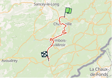
17,1 km | 25 km-effort
6h 35min
Oui
Randonnée Marche Belleherbe - circuit Montaigu - Photo
Marche
pfaffjocelyne

Marche

Très facile
Belleherbe, Bourgogne-Franche-Comté, Doubs, France
11,9 km | 15,2 km-effort
2h 46min
Oui
Randonnée Marche Vaucluse - vaucluse - Photo
Marche
cherlieu

Marche

Très difficile
Vaucluse, Bourgogne-Franche-Comté, Doubs, France
20 km | 29 km-effort
6h 10min
Oui
Randonnée Marche Vaucluse - vaucluse - Photo
Marche
eltonnermou

Marche

Moyen
Vaucluse, Bourgogne-Franche-Comté, Doubs, France
14,9 km | 20 km-effort
2h 25min
Oui
Randonnée Autre activité Charmoille - charmoille - Photo
Autre activité
alexbnmr

Autre activité

Très facile
(1)
Charmoille, Bourgogne-Franche-Comté, Doubs, France
25 km | 31 km-effort
4h 17min
Non
Randonnée Marche Chamesey - 123 - Photo
Marche
cherlieu

Marche

Très difficile
Chamesey, Bourgogne-Franche-Comté, Doubs, France
41 km | 58 km-effort
12h 45min
Oui
Randonnée Marche Belleherbe - belleherbe - Photo
Marche
cherlieu

Marche

Difficile
Belleherbe, Bourgogne-Franche-Comté, Doubs, France
22 km | 31 km-effort
8h 13min
Oui
Randonnée Marche Chamesey - chamesey - Photo
Marche
cherlieu

Marche

Difficile
Chamesey, Bourgogne-Franche-Comté, Doubs, France
19,7 km | 29 km-effort
7h 0min
Oui
Randonnée sport Chamesey -  - Photo
sport
cherlieu

sport

Très facile
Chamesey, Bourgogne-Franche-Comté, Doubs, France
18,1 km | 27 km-effort
Inconnu
Oui


Fermer
Mes abonnements