Randonnée V.T.T. Montholon - aillant 2023 - Photo
 Vincent Poupart
Vincent Poupart

Utilisateur

© OpenStreetMap contributors
Longueur
Longueur
19,9 km
Altitude max
Altitude max
250 m
Dénivelé positif
Dénivelé positif
263 m
Km-Effort
Km-Effort  
24 km
Altitude min
Altitude min
109 m
Dénivelé négatif
Dénivelé négatif
364 m
Boucle
Boucle
Non
Date de création :
2023-03-12 08:32:33.766
Dernière modification :
2023-03-12 12:26:34.131

(0 Avis)

V.T.T.
V.T.T.
1h00
Difficulté : Moyen

Scannez ce code QR pour ouvrir la randonnée dans l'application SityTrail

Application GPS de randonnée GRATUITE

Logo SityTrail SityTrail

IGN / Instituts géographiques

Télécharger SityTrail sur l'App Store Télécharger SityTrail sur Google Play

Logo SityTrail SityTrail World

Le monde est à vous

Télécharger SityTrail sur l'App Store Télécharger SityTrail sur Google Play Télécharger SityTrail sur Huawei AppGallery

À propos

Randonnée V.T.T. de 19,9 km à découvrir à Bourgogne-Franche-Comté, Yonne, Montholon. Cette randonnée est proposée par Vincent Poupart.

Profil altimétrique

Localisation

Pays :
France
Région :
Bourgogne-Franche-Comté
Département/Province :
Yonne
Commune :
Montholon
Localité :
Unknown
Départ:(UTM)
523925 ; 5303831 (31T) N.

Randonnées à proximité

Randonnée Marche Montholon - La grande boucle -  Aillant-sur-Tholon - Photo
Marche
tracegps

Marche

Très difficile
Montholon, Bourgogne-Franche-Comté, Yonne, France
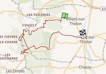
18,9 km | 22 km-effort
4h 45min
Oui
Randonnée Marche Montholon - Les Ferriers -  Aillant-sur-Tholon - Photo
Marche
tracegps

Marche

Difficile
Montholon, Bourgogne-Franche-Comté, Yonne, France
14,3 km | 17 km-effort
3h 30min
Oui
Randonnée Marche Montholon - La Croix de l'Orme -  Aillant-sur-Tholon - Photo
Marche
tracegps

Marche

Facile
(1)
Montholon, Bourgogne-Franche-Comté, Yonne, France
6,3 km | 6,9 km-effort
1h 34min
Oui
Randonnée Marche Montholon - La cour aux lièvres  -  Aillant-sur-Tholon - Photo
Marche
tracegps

Marche

Facile
Montholon, Bourgogne-Franche-Comté, Yonne, France
5,6 km | 6,6 km-effort
1h 25min
Oui
Randonnée V.T.T. Les Ormes - juss - Photo
V.T.T.
Vincent Poupart

V.T.T.

Moyen
Les Ormes, Bourgogne-Franche-Comté, Yonne, France
58 km | 71 km-effort
2h 17min
Non
Randonnée Autre activité Chassy - footing sympa  - Photo
Autre activité
christopheusj

Autre activité

Facile
Chassy, Bourgogne-Franche-Comté, Yonne, France
23 km | 28 km-effort
2h 8min
Oui
Randonnée Autre activité Montholon - g - Photo
Autre activité
dede8900

Autre activité

Très facile
Montholon, Bourgogne-Franche-Comté, Yonne, France
10,1 km | 12,4 km-effort
1h 58min
Oui
Randonnée Vélo électrique Montholon - vae Villiers  - Photo
Vélo électrique
domipath

Vélo électrique

Très facile
Montholon, Bourgogne-Franche-Comté, Yonne, France
23 km | 27 km-effort
1h 7min
Non
Randonnée V.T.T. Montholon - villier explo  - Photo
V.T.T.
Vincent Poupart

V.T.T.

Facile
Montholon, Bourgogne-Franche-Comté, Yonne, France
11,5 km | 15,7 km-effort
1h 0min
Oui


Fermer
Mes abonnements