Metzeral / Petit Ballon / Strohberg...

boubou68
Utilisateur
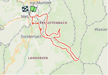

Longueur
18,3 km

Altitude max
1266 m

Dénivelé positif
838 m
Km-Effort
30 km

Altitude min
477 m

Dénivelé négatif
840 m
Boucle
Oui
Date de création :
2023-04-03 11:09:12.491
Dernière modification :
2023-04-03 11:09:13.172
6h42
Difficulté : Très difficile

Application GPS de randonnée GRATUITE
 SityTrail
IGN / Instituts géographiques
SityTrail Plus
Le monde est à vous
À propos
Randonnée Marche de 18,3 km à découvrir à Grand Est, Haut-Rhin, Metzeral. Cette randonnée est proposée par boubou68.
Description
RAS
Localisation
Pays :
France
Région :
Grand Est
Département/Province :
Haut-Rhin
Commune :
Metzeral
Localité :
Unknown
Départ:(Dec)
Départ:(UTM)
356189 ; 5319575 (32U) N.
Commentaires