


Col du Hundsruck

philvor
Utilisateur
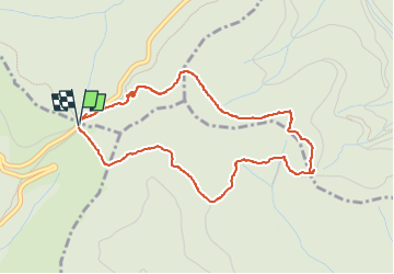

Longueur
4,3 km

Altitude max
851 m

Dénivelé positif
175 m
Km-Effort
6,7 km

Altitude min
702 m

Dénivelé négatif
173 m
Boucle
Oui
Date de création :
2023-04-06 12:43:47.0
Dernière modification :
2023-04-06 14:19:55.579
1h15
Difficulté : Moyen

Application GPS de randonnée GRATUITE
 SityTrail
IGN / Instituts géographiques
SityTrail Plus
Le monde est à vous
À propos
Randonnée Marche de 4,3 km à découvrir à Grand Est, Haut-Rhin, Bourbach-le-Haut. Cette randonnée est proposée par philvor.
Description
Hundsruck sentier Batman
Localisation
Pays :
France
Région :
Grand Est
Département/Province :
Haut-Rhin
Commune :
Bourbach-le-Haut
Localité :
Unknown
Départ:(Dec)
Départ:(UTM)
353444 ; 5296631 (32T) N.
Commentaires