Randonnée Marche Crans-Montana - Aminona-Leukerbad - Photo

Randonnées de la Maison du tourisme de Crans-Montana GUIDE+

© OpenStreetMap contributors
Longueur
Longueur
17,7 km
Altitude max
Altitude max
2233 m
Dénivelé positif
Dénivelé positif
652 m
Km-Effort
Km-Effort  
28 km
Altitude min
Altitude min
1368 m
Dénivelé négatif
Dénivelé négatif
1037 m
Boucle
Boucle
Non
Date de création :
2014-12-10 00:00:00.0
Dernière modification :
2014-12-10 00:00:00.0

(0 Avis)

Marche
Marche
6h23
Difficulté : Inconnu

Scannez ce code QR pour ouvrir la randonnée dans l'application SityTrail

Application GPS de randonnée GRATUITE

Logo SityTrail SityTrail

IGN / Instituts géographiques

Télécharger SityTrail sur l'App Store Télécharger SityTrail sur Google Play

Logo SityTrail SityTrail World

Le monde est à vous

Télécharger SityTrail sur l'App Store Télécharger SityTrail sur Google Play Télécharger SityTrail sur Huawei AppGallery

À propos

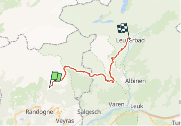
Randonnée Marche de 17,7 km à découvrir à Valais, Sierre, Crans-Montana. Cette randonnée est proposée par Maison du Tourisme Crans-Montana.

Description

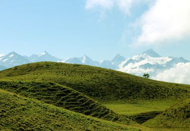
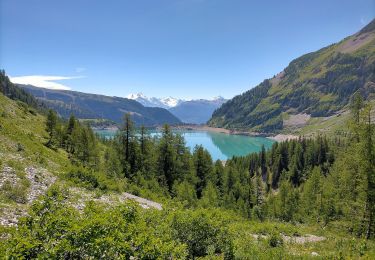
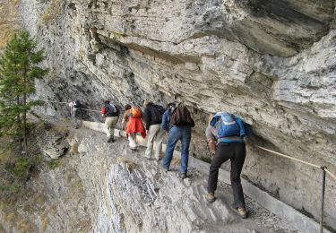
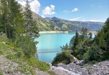
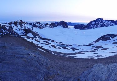
Discover the wealth and diversity of flora on the Varen alpine pasture plateau , the Varneralp. This walk follows the bisse du Tsittoret to the Tièche. On the way,  walkers can enjoy the marvellous landscape before reaching the source of the bisse and, at last, the Tièche waterfalls. 12,000 years ago, this wonderful place was covered by a glacier.

The walk continues along the hillside of the Varen alpine pasture, with an impressive view over the Haut-Valais region. Then a long descent leads you down to Leukerbad, where you can relax in the resort''s thermal waters.

Profil altimétrique

Localisation

Pays :
Suisse
Région :
Valais
Département/Province :
Sierre
Commune :
Crans-Montana
Localité :
Mollens (VS)
Départ:(Dec)
Départ:(UTM)
385782 ; 5132264 (32T) N.

Randonnées à proximité

Randonnée Marche Crans-Montana - Sentier de Huiton - Photo
Marche
GUIDE+

Marche

Très facile
(2)
Crans-Montana, Valais, Sierre, Suisse
7,1 km | 10,9 km-effort
2h 17min
Non
Randonnée V.T.T. Crans-Montana - Tour des villages - Photo
V.T.T.
GUIDE+

V.T.T.

Très facile
(1)
Crans-Montana, Valais, Sierre, Suisse
23 km | 35 km-effort
3h 0min
Oui
Randonnée A pied Crans-Montana - Montagne du Plan - Trubelstock - Photo
A pied
PRO

A pied

Facile
Crans-Montana, Valais, Sierre, Suisse
3,8 km | 12,5 km-effort
2h 50min
Non
Randonnée A pied Lens - Cran - Er de Chermignon (Ancien bisse du Ro) - Photo
A pied
PRO

A pied

Facile
Lens, Valais, Sierre, Suisse
6,1 km | 11,5 km-effort
2h 37min
Non
Randonnée A pied Icogne - Pra du taillour-Pas de l'ours - Photo
A pied
PRO

A pied

Facile
Icogne, Valais, Sierre, Suisse
4 km | 7,6 km-effort
1h 42min
Non
Randonnée A pied Icogne - Er de Chermignon-Pra du Taillour - Photo
A pied
PRO

A pied

Facile
Icogne, Valais, Sierre, Suisse
6,4 km | 10,2 km-effort
2h 19min
Non
Randonnée A pied Crans-Montana - Plaine Morte-Les Violettes - Photo
A pied
PRO

A pied

Facile
Crans-Montana, Valais, Sierre, Suisse
4,5 km | 11,5 km-effort
2h 36min
Non
Randonnée Marche Sierre - Sierre à Chandolin - Photo
Marche
chandolin

Marche

Très facile
(1)
Sierre, Valais, Sierre, Suisse
11,5 km | 28 km-effort
7h 24min
Non
Randonnée V.T.T. Crans-Montana - Tour Hauts de Crans - Photo
V.T.T.
GUIDE+

V.T.T.

Très facile
Crans-Montana, Valais, Sierre, Suisse
7,8 km | 11,3 km-effort
1h 30min
Oui


Fermer
Mes abonnements