


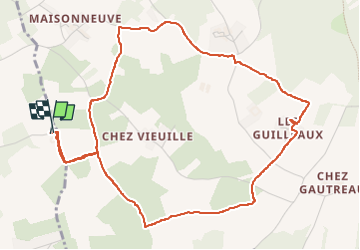

7,2 km | 8,5 km-effort


Utilisateur


Application GPS de randonnée GRATUITE
 SityTrail
IGN / Instituts géographiques
SityTrail World
Le monde est à vous
Randonnée Marche de 5,8 km à découvrir à Nouvelle-Aquitaine, Charente-Maritime, Bussac-sur-Charente. Cette randonnée est proposée par BPoupard.

Cheval

Marche

Vélo électrique
Marche
Marche

Autre activité
Marche
V.T.T.

V.T.T.