


Saint léger

veroberton
Utilisateur
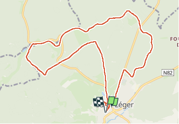

Longueur
11,8 km

Altitude max
350 m

Dénivelé positif
226 m
Km-Effort
14,9 km

Altitude min
266 m

Dénivelé négatif
226 m
Boucle
Oui
Date de création :
2023-05-22 12:46:35.32
Dernière modification :
2023-05-22 16:03:32.394
3h15
Difficulté : Facile

Application GPS de randonnée GRATUITE
 SityTrail
IGN / Instituts géographiques
SityTrail Plus
Le monde est à vous
À propos
Randonnée Marche de 11,8 km à découvrir à Wallonie, Luxembourg, Saint-Léger. Cette randonnée est proposée par veroberton.
Localisation
Pays :
Belgique
Région :
Wallonie
Département/Province :
Luxembourg
Commune :
Saint-Léger
Localité :
Saint-Léger
Départ:(Dec)
Départ:(UTM)
691725 ; 5498833 (31U) N.
Commentaires