


Étape 2 2023

Pascal Bernaud
Utilisateur
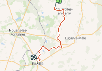

Longueur
21 km

Altitude max
176 m

Dénivelé positif
193 m
Km-Effort
24 km

Altitude min
104 m

Dénivelé négatif
191 m
Boucle
Non
Date de création :
2023-05-23 06:29:31.0
Dernière modification :
2023-05-23 13:29:35.009
6h59
Difficulté : Très difficile

Application GPS de randonnée GRATUITE
 SityTrail
IGN / Instituts géographiques
SityTrail Plus
Le monde est à vous
À propos
Randonnée Marche de 21 km à découvrir à Centre-Val de Loire, Indre, Villentrois-Faverolles-en-Berry. Cette randonnée est proposée par Pascal Bernaud.
Localisation
Pays :
France
Région :
Centre-Val de Loire
Département/Province :
Indre
Commune :
Villentrois-Faverolles-en-Berry
Localité :
Faverolles-en-Berry
Départ:(Dec)
Départ:(UTM)
377860 ; 5226133 (31T) N.
Commentaires