


7_8 juillet option 3

maureengeorges
Utilisateur
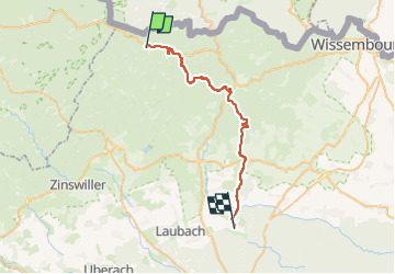

Longueur
30 km

Altitude max
441 m

Dénivelé positif
651 m
Km-Effort
39 km

Altitude min
146 m

Dénivelé négatif
730 m
Boucle
Non
Date de création :
2023-05-30 17:23:05.344
Dernière modification :
2023-05-30 17:24:52.808
5h10
Difficulté : Difficile

Application GPS de randonnée GRATUITE
 SityTrail
IGN / Instituts géographiques
SityTrail Plus
Le monde est à vous
À propos
Randonnée Randonnée équestre de 30 km à découvrir à Grand Est, Bas-Rhin, Obersteinbach. Cette randonnée est proposée par maureengeorges.
Localisation
Pays :
France
Région :
Grand Est
Département/Province :
Bas-Rhin
Commune :
Obersteinbach
Localité :
Unknown
Départ:(Dec)
Départ:(UTM)
403401 ; 5432163 (32U) N.
Commentaires