


conversaria pic st Michel

lionelnottat
Utilisateur
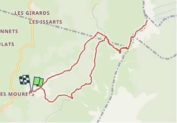

Longueur
12,4 km

Altitude max
1965 m

Dénivelé positif
841 m
Km-Effort
24 km

Altitude min
1173 m

Dénivelé négatif
845 m
Boucle
Oui
Date de création :
2023-06-20 06:49:19.351
Dernière modification :
2023-06-20 12:39:24.148
3h54
Difficulté : Difficile
3h54
Difficulté : Moyen

Application GPS de randonnée GRATUITE
 SityTrail
IGN / Instituts géographiques
SityTrail Plus
Le monde est à vous
À propos
Randonnée Marche de 12,4 km à découvrir à Auvergne-Rhône-Alpes, Isère, Villard-de-Lans. Cette randonnée est proposée par lionelnottat.
Localisation
Pays :
France
Région :
Auvergne-Rhône-Alpes
Département/Province :
Isère
Commune :
Villard-de-Lans
Localité :
Unknown
Départ:(Dec)
Départ:(UTM)
703060 ; 4994232 (31T) N.
Commentaires