Randonnée Marche Consdorf - Consdorf - Sentier local C1  - Photo

Consdorf - Sentier local C1

 mumu.larandonneuse
mumu.larandonneuse

Utilisateur GUIDE

© OpenStreetMap contributors
Longueur
Longueur
1,9 km
Altitude max
Altitude max
334 m
Dénivelé positif
Dénivelé positif
43 m
Km-Effort
Km-Effort  
2,5 km
Altitude min
Altitude min
295 m
Dénivelé négatif
Dénivelé négatif
43 m
Boucle
Boucle
Oui
Date de création :
2023-06-21 15:04:10.502
Dernière modification :
2023-06-24 14:23:44.227

(1 Avis)

Marche
Marche
34m
Difficulté : Facile

Scannez ce code QR pour ouvrir la randonnée dans l'application SityTrail

Application GPS de randonnée GRATUITE

Logo SityTrail SityTrail

IGN / Instituts géographiques

Télécharger SityTrail sur l'App Store Télécharger SityTrail sur Google Play

Logo SityTrail SityTrail World

Le monde est à vous

Télécharger SityTrail sur l'App Store Télécharger SityTrail sur Google Play Télécharger SityTrail sur Huawei AppGallery

À propos

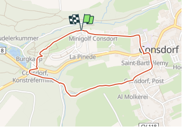
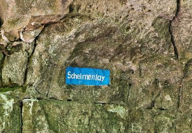
Randonnée Marche de 1,9 km à découvrir à Inconnu, Canton Echternach, Consdorf. Cette randonnée est proposée par mumu.larandonneuse.

Description

ℹ️ www.mullerthal-trail.lu
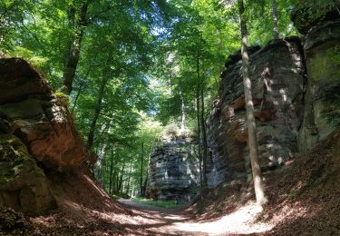
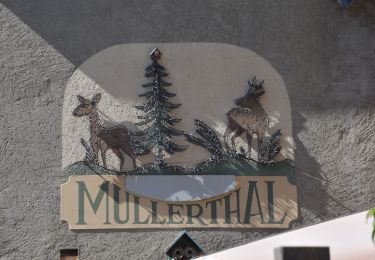
➡️Cette courte randonnée vous donne une belle première impression des formations rocheuses bizarres de la Région Mullerthal - Petite Suisse Luxembourgeoise.

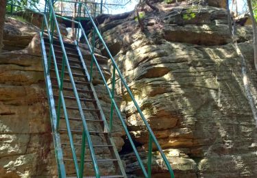
Cet itinéraire plutôt court passe par de petits sentiers. Il vous mène dans la vallée à travers une crevasse étroite. Faites attention sur les marches qui peuvent être glissantes.  Au niveau de la route, vous aurez déjà fait la moitié du chemin.

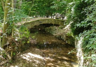
De là, le chemin monte à nouveau, longe l'imposant paysage rocheux et retourne à Consdorf.

Profil altimétrique

Photos

Localisation

Pays :
Luxembourg
Région :
Inconnu
Département/Province :
Canton Echternach
Commune :
Consdorf
Localité :
Unknown
Départ:(UTM)
307913 ; 5517682 (32U) N.

Commentaires

Veuillez vous connecter pour laisser un commentaire ou une note


Depuis le camping ⛺️ La Pinède, parcours combiné C1 & C2


Randonnées à proximité

Randonnée Marche Consdorf - Consdorf - C6 - Photo
Marche
GUIDE
mumu.larandonneuse

Marche

Moyen
(1)
Consdorf, Inconnu, Canton Echternach, Luxembourg
5,8 km | 7,3 km-effort
1h 39min
Oui
Randonnée Marche Consdorf - Consdorf - C2 (Müllerthal) - Photo
Marche
GUIDE
mumu.larandonneuse

Marche

Facile
(1)
Consdorf, Inconnu, Canton Echternach, Luxembourg
4,2 km | 5,5 km-effort
1h 15min
Oui
Randonnée Marche Consdorf - Consdorf - Mullerthal - Photo
Marche
GUIDE
mumu.larandonneuse

Marche

Moyen
(1)
Consdorf, Inconnu, Canton Echternach, Luxembourg
9 km | 12,3 km-effort
2h 48min
Oui
Randonnée Marche Berdorf - Berdorf - B2 - Müllerthal - Photo
Marche
GUIDE
mumu.larandonneuse

Marche

Moyen
(1)
Berdorf, Inconnu, Canton Echternach, Luxembourg
6,7 km | 8,5 km-effort
1h 35min
Oui
Randonnée Marche Berdorf - Berdorf - B8 - Müllerthal - Photo
Marche
GUIDE
mumu.larandonneuse

Marche

Moyen
(1)
Berdorf, Inconnu, Canton Echternach, Luxembourg
11,7 km | 15 km-effort
3h 24min
Oui
Randonnée Marche Waldbillig - Mullerthal randonnée magnifique - Photo
Marche
Alfredy

Marche

Difficile
(4)
Waldbillig, Inconnu, Canton Echternach, Luxembourg
9,3 km | 12,9 km-effort
4h 21min
Oui
Randonnée Marche Waldbillig - MÜLLERTHAL (Cascades) - Photo
Marche
GerardBouche

Marche

Moyen
(1)
Waldbillig, Inconnu, Canton Echternach, Luxembourg
10,2 km | 13,7 km-effort
3h 1min
Oui
Randonnée Autre activité Waldbillig - Luxemburg: Mullerthal - Consdorf - Mullerthal - Photo
Autre activité
mikeryckmans

Autre activité

Très difficile
(3)
Waldbillig, Inconnu, Canton Echternach, Luxembourg
11,5 km | 15,4 km-effort
4h 10min
Oui
Randonnée Marche Waldbillig - 20220525 - Mullertal 11.7 Km - Photo
Marche
GUIDE
pierreh01

Marche

Moyen
Waldbillig, Inconnu, Canton Echternach, Luxembourg
11,7 km | 15,4 km-effort
4h 31min
Oui


Fermer
Mes abonnements