Randonnée Marche Sainte-Paule - Col du chêne - Photo
 fernand1254
fernand1254

Utilisateur

© OpenStreetMap contributors
Longueur
Longueur
9 km
Altitude max
Altitude max
802 m
Dénivelé positif
Dénivelé positif
357 m
Km-Effort
Km-Effort  
13,8 km
Altitude min
Altitude min
515 m
Dénivelé négatif
Dénivelé négatif
358 m
Boucle
Boucle
Oui
Date de création :
2023-07-04 06:56:52.132
Dernière modification :
2023-07-04 09:34:33.655

(0 Avis)

Marche
Marche
2h37
Difficulté : Facile

Scannez ce code QR pour ouvrir la randonnée dans l'application SityTrail

Application GPS de randonnée GRATUITE

Logo SityTrail SityTrail

IGN / Instituts géographiques

Télécharger SityTrail sur l'App Store Télécharger SityTrail sur Google Play

Logo SityTrail SityTrail World

Le monde est à vous

Télécharger SityTrail sur l'App Store Télécharger SityTrail sur Google Play Télécharger SityTrail sur Huawei AppGallery

À propos

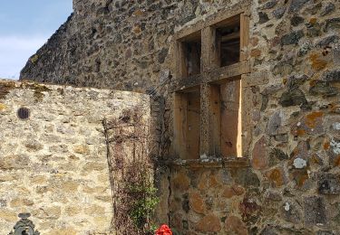
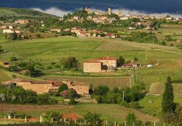
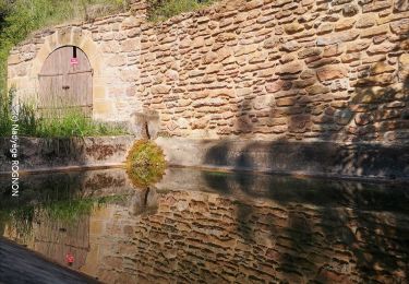
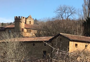
Randonnée Marche de 9 km à découvrir à Auvergne-Rhône-Alpes, Rhône, Sainte-Paule. Cette randonnée est proposée par fernand1254.

Description

Belle rando sympa. Parcours varié.

Profil altimétrique

Localisation

Pays :
France
Région :
Auvergne-Rhône-Alpes
Département/Province :
Rhône
Commune :
Sainte-Paule
Localité :
Unknown
Départ:(UTM)
621187 ; 5093983 (31T) N.

Randonnées à proximité

Randonnée Marche Ternand - Ternand - Létra - Photo
Marche
daniellebou

Marche

Très difficile
(1)
Ternand, Auvergne-Rhône-Alpes, Rhône, France
17,8 km | 27 km-effort
6h 7min
Oui
Randonnée Marche Val d'Oingt - Oingt (69) Beaujolais  - Photo
Marche
Thomasdanielle

Marche

Très facile
(1)
Val d'Oingt, Auvergne-Rhône-Alpes, Rhône, France
9,3 km | 13,3 km-effort
2h 30min
Oui
Randonnée Marche Montmelas-Saint-Sorlin - Col de Saint Bonnet (13-09-18)  - Photo
Marche
Thomasdanielle

Marche

Facile
(1)
Montmelas-Saint-Sorlin, Auvergne-Rhône-Alpes, Rhône, France
8,1 km | 11,9 km-effort
2h 29min
Oui
Randonnée Marche Saint-Cyr-le-Chatoux - Saint-cyr-le-Chatoux
Marche
Thomasdanielle

Marche

Moyen
(2)
Saint-Cyr-le-Chatoux, Auvergne-Rhône-Alpes, Rhône, France
11,7 km | 16,7 km-effort
3h 45min
Oui
Randonnée Marche Sainte-Paule - Sainte-Paule (13,4 km D. 485 m) - Photo
Marche
Thomasdanielle

Marche

Moyen
(1)
Sainte-Paule, Auvergne-Rhône-Alpes, Rhône, France
13,4 km | 19,4 km-effort
4h 9min
Oui
Randonnée Marche Rivolet - Rivolet - Photo
Marche
jpcoco

Marche

Moyen
(2)
Rivolet, Auvergne-Rhône-Alpes, Rhône, France
11,1 km | 17,2 km-effort
3h 42min
Non
Randonnée Marche Val d'Oingt - Saint-Laurent d'Oingt - Oingt, Plus beau Village de France - Photo
Marche
adye

Marche

Difficile
Val d'Oingt, Auvergne-Rhône-Alpes, Rhône, France
8,8 km | 12,5 km-effort
2h 20min
Oui
Randonnée Marche Val d'Oingt - 69620-Saint-Laurent d'Oingt-Bois d'Oingt : lavoirs, château et coteaux - Photo
Marche
adye

Marche

Moyen
Val d'Oingt, Auvergne-Rhône-Alpes, Rhône, France
8 km | 11 km-effort
1h 57min
Oui
Randonnée Marche Val d'Oingt - Oingt en Beaujolais (13 km - D. 405 m) - Photo
Marche
Thomasdanielle

Marche

Moyen
Val d'Oingt, Auvergne-Rhône-Alpes, Rhône, France
13,4 km | 18,8 km-effort
4h 58min
Oui


Fermer
Mes abonnements