![](/images/other/stat-length.png)
![Randonnée Marche Bordes-Uchentein - Estagnous - Photo](https://media.geolcdn.com/t/1900/400/ext.pjpeg?maxdim=2&url=https%3A%2F%2Fmedia.geolcdn.com%2Ff%2Ffaa926ef-143c-48e7-953f-0c21d5e2c304.jpg)
Estagnous
georghinio
Utilisateur
![Longueur](/images/other/stat-length.png)
Longueur
16,5 km
![Altitude max](https://static1.geolcdn.com/siteimages/upload/files/1508320355ic_sort_altitude_max_24dp.png)
Altitude max
2243 m
![Dénivelé positif](https://static1.geolcdn.com/siteimages/upload/files/1508320355ic_sort_den_pos_24dp.png)
Dénivelé positif
1314 m
![Km-Effort](/images/other/stat-length.png)
Km-Effort
34 km
![Altitude min](https://static1.geolcdn.com/siteimages/upload/files/1508320355ic_sort_altitude_min_24dp.png)
Altitude min
941 m
![Dénivelé négatif](https://static1.geolcdn.com/siteimages/upload/files/1508320355ic_sort_den_neg_24dp.png)
Dénivelé négatif
1316 m
![Boucle](https://static1.geolcdn.com/siteimages/upload/files/16400158638029165_repeat_loop_refresh_sync_direction_icon.png)
Boucle
Non
Date de création :
2023-06-30 07:29:54.0
Dernière modification :
2023-07-06 10:48:42.879
![Marche](https://static1.geolcdn.com/sitytour/trail-icons/101.png)
7h43
Difficulté : Très difficile
![Scannez ce code QR pour ouvrir la randonnée dans l'application SityTrail](https://capi.geolives.com/qq0zvz2zws4bq2lad0pu/sitytour/trails/3722214/qr.png?size=200)
Application GPS de randonnée GRATUITE
À propos
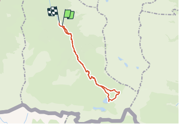
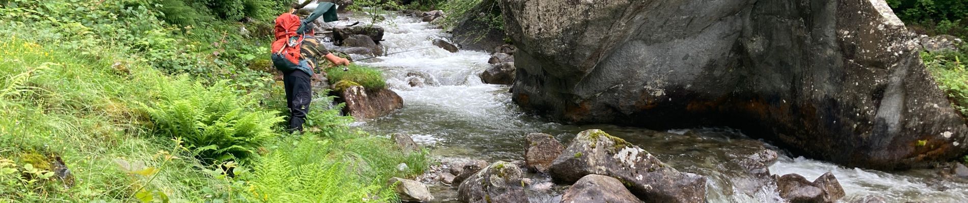
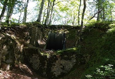
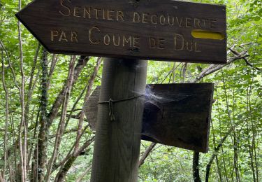
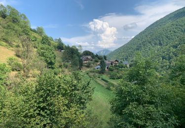
Randonnée Marche de 16,5 km à découvrir à Occitanie, Ariège, Bordes-Uchentein. Cette randonnée est proposée par georghinio.
Description
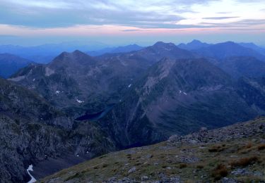
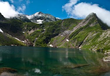
Aller retour au refuge des Estagnous, pas de possibilité ce jour là de monter au Vallier mauvaise météo, passage à l'aller par l'étang rond.
Localisation
Pays :
France
Région :
Occitanie
Département/Province :
Ariège
Commune :
Bordes-Uchentein
Localité :
Les Bordes-sur-Lez
Départ:(Dec)
Départ:(UTM)
339235 ; 4743929 (31T) N.
Commentaires
Randonnées à proximité
![Randonnée Marche Bethmale - Bethmale - Photo](https://media.geolcdn.com/t/375/260/ext.jpg?maxdim=2&url=https%3A%2F%2Fservices.sitytrail.com%2FGeolivesWS%2FDownloadMedia.ashx%3FTrailID%3D205667%26Media%3Dfix__20130713122146.jpg)
![Marche Marche](https://static1.geolcdn.com/sitytour/trail-icons/101.png)
![Randonnée Marche Bethmale - Circuit des cinq étangs (2237m) - Photo](https://media.geolcdn.com/t/375/260/ext.jpg?maxdim=2&url=https%3A%2F%2Fstatic1.geolcdn.com%2Fsiteimages%2Fupload%2Ffiles%2F1553511878bg_sport_marche.png)
![Marche Marche](https://static1.geolcdn.com/sitytour/trail-icons/101.png)
Circuit des cinq étangs (2237m)
Marche
Difficile
(3)
Bethmale,
Occitanie,
Ariège,
France
![](/images/other/stat-length.png)
18,1 km | 33 km-effort
Inconnu
![](https://static1.geolcdn.com/siteimages/upload/files/16400158638029165_repeat_loop_refresh_sync_direction_icon.png)
Oui
![Randonnée Marche Bordes-Uchentein - Pic de la Pale de la Clauère - Photo](https://media.geolcdn.com/t/375/260/ext.jpg?maxdim=2&url=https%3A%2F%2Fstatic1.geolcdn.com%2Fsiteimages%2Fupload%2Ffiles%2F1553511878bg_sport_marche.png)
![Marche Marche](https://static1.geolcdn.com/sitytour/trail-icons/101.png)
Pic de la Pale de la Clauère
Marche
Très difficile
(1)
Bordes-Uchentein,
Occitanie,
Ariège,
France
![](/images/other/stat-length.png)
7,7 km | 20 km-effort
4h 1min
![](https://static1.geolcdn.com/siteimages/upload/files/16400158638029165_repeat_loop_refresh_sync_direction_icon.png)
Oui
![Randonnée Marche Bonac-Irazein - tunnels du Biros ou sentier Decauville - Photo](https://media.geolcdn.com/t/375/260/ext.jpg?maxdim=2&url=https%3A%2F%2Fmedia.geolcdn.com%2Ff%2F2ced53d3-2fbe-4fc5-97f5-bde97ee00210.jpg)
![Marche Marche](https://static1.geolcdn.com/sitytour/trail-icons/101.png)
tunnels du Biros ou sentier Decauville
Marche
Très difficile
Bonac-Irazein,
Occitanie,
Ariège,
France
![](/images/other/stat-length.png)
17,8 km | 29 km-effort
6h 35min
![](https://static1.geolcdn.com/siteimages/upload/files/16400158638029165_repeat_loop_refresh_sync_direction_icon.png)
Oui
![Randonnée Marche Bonac-Irazein - Sentier du port d’Orle - col du Tuc - Photo](https://media.geolcdn.com/t/375/260/ext.jpg?maxdim=2&url=https%3A%2F%2Fmedia.geolcdn.com%2Ff%2F74662a78-0f2f-48cd-8c55-5df1361685fc.jpg)
![Marche Marche](https://static1.geolcdn.com/sitytour/trail-icons/101.png)
Sentier du port d’Orle - col du Tuc
Marche
Facile
Bonac-Irazein,
Occitanie,
Ariège,
France
![](/images/other/stat-length.png)
13,7 km | 27 km-effort
6h 20min
![](https://static1.geolcdn.com/siteimages/upload/files/16400158638029165_repeat_loop_refresh_sync_direction_icon.png)
Oui
![Randonnée Marche Bordes-Uchentein - 2022 TRANSPYRÉNÉENNE - refuge du Valier -refuge d’Esbints - Photo](https://media.geolcdn.com/t/375/260/ext.jpg?maxdim=2&url=https%3A%2F%2Fmedia.geolcdn.com%2Ff%2F2e9343d2-a60c-4833-91b2-9c5dc0d9f716.jpg)
![Marche Marche](https://static1.geolcdn.com/sitytour/trail-icons/101.png)
2022 TRANSPYRÉNÉENNE - refuge du Valier -refuge d’Esbints
Marche
Très difficile
Bordes-Uchentein,
Occitanie,
Ariège,
France
![](/images/other/stat-length.png)
18,5 km | 35 km-effort
5h 25min
![](https://static1.geolcdn.com/siteimages/upload/files/16400158638029165_repeat_loop_refresh_sync_direction_icon.png)
Non
![Randonnée A pied Bethmale - Grand circuit dans la Réserve Naturelle du Mont Valier - Photo](https://media.geolcdn.com/t/375/260/ext.jpg?maxdim=2&url=https%3A%2F%2Fmedia.geolcdn.com%2Ff%2F5ad9c477-0f32-4002-9a96-1c99cc53104c.jpeg)
![A pied A pied](https://static1.geolcdn.com/sitytour/trail-icons/100.png)
Grand circuit dans la Réserve Naturelle du Mont Valier
A pied
Facile
Bethmale,
Occitanie,
Ariège,
France
![](/images/other/stat-length.png)
9,5 km | 19,6 km-effort
4h 26min
![](https://static1.geolcdn.com/siteimages/upload/files/16400158638029165_repeat_loop_refresh_sync_direction_icon.png)
Non
![Randonnée A pied Bordes-Uchentein - Étangs Long et Rond - Photo](https://media.geolcdn.com/t/375/260/ext.jpg?maxdim=2&url=https%3A%2F%2Fmedia.geolcdn.com%2Ff%2Fa3cac1de-06a6-41d0-ac66-ed9400aa294d.jpeg)
![A pied A pied](https://static1.geolcdn.com/sitytour/trail-icons/100.png)
Étangs Long et Rond
A pied
Difficile
Bordes-Uchentein,
Occitanie,
Ariège,
France
![](/images/other/stat-length.png)
15,8 km | 36 km-effort
8h 7min
![](https://static1.geolcdn.com/siteimages/upload/files/16400158638029165_repeat_loop_refresh_sync_direction_icon.png)
Non
![Randonnée Marche Bethmale - refuge Salvador - Photo](https://media.geolcdn.com/t/375/260/ext.jpg?maxdim=2&url=https%3A%2F%2Fmedia.geolcdn.com%2Ff%2F41221468-6f9e-4614-8cc9-9cc4dfd6562d.jpg)
![Marche Marche](https://static1.geolcdn.com/sitytour/trail-icons/101.png)
refuge Salvador
Marche
Très difficile
Bethmale,
Occitanie,
Ariège,
France
![](/images/other/stat-length.png)
16 km | 25 km-effort
5h 46min
![](https://static1.geolcdn.com/siteimages/upload/files/16400158638029165_repeat_loop_refresh_sync_direction_icon.png)
Oui