


Parking Cimetière de Le Thillot - Chaillon - Col de Foigneux - La Revanche - Pic des Corbeaux et retour

patrickbeyrath
Utilisateur
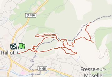

Longueur
7,9 km

Altitude max
776 m

Dénivelé positif
345 m
Km-Effort
12,5 km

Altitude min
511 m

Dénivelé négatif
344 m
Boucle
Oui
Date de création :
2023-08-01 09:51:19.851
Dernière modification :
2023-08-04 07:37:40.837
2h50
Difficulté : Moyen

Application GPS de randonnée GRATUITE
 SityTrail
IGN / Instituts géographiques
SityTrail Plus
Le monde est à vous
À propos
Randonnée Marche de 7,9 km à découvrir à Grand Est, Vosges, Le Thillot. Cette randonnée est proposée par patrickbeyrath.
Localisation
Pays :
France
Région :
Grand Est
Département/Province :
Vosges
Commune :
Le Thillot
Localité :
Unknown
Départ:(Dec)
Départ:(UTM)
333067 ; 5305410 (32T) N.
Commentaires