![](/images/other/stat-length.png)
![Randonnée Marche Villers-la-Ville - #230804 - Villers-la-Ville > Basse Heuval dont 3 km de GR**** - Photo](https://media.geolcdn.com/t/1900/400/ext.pjpeg?maxdim=2&url=https%3A%2F%2Fstatic1.geolcdn.com%2Fsiteimages%2Fupload%2Ffiles%2F1553511878bg_sport_marche.png)
#230804 - Villers-la-Ville > Basse Heuval dont 3 km de GR****
Randos Ouvertes
Utilisateur
![Longueur](/images/other/stat-length.png)
Longueur
5,7 km
![Altitude max](https://static1.geolcdn.com/siteimages/upload/files/1508320355ic_sort_altitude_max_24dp.png)
Altitude max
159 m
![Dénivelé positif](https://static1.geolcdn.com/siteimages/upload/files/1508320355ic_sort_den_pos_24dp.png)
Dénivelé positif
106 m
![Km-Effort](/images/other/stat-length.png)
Km-Effort
7,1 km
![Altitude min](https://static1.geolcdn.com/siteimages/upload/files/1508320355ic_sort_altitude_min_24dp.png)
Altitude min
116 m
![Dénivelé négatif](https://static1.geolcdn.com/siteimages/upload/files/1508320355ic_sort_den_neg_24dp.png)
Dénivelé négatif
108 m
![Boucle](https://static1.geolcdn.com/siteimages/upload/files/16400158638029165_repeat_loop_refresh_sync_direction_icon.png)
Boucle
Oui
Date de création :
2023-08-04 13:38:05.381
Dernière modification :
2023-08-04 13:39:19.886
![Marche](https://static1.geolcdn.com/sitytour/trail-icons/101.png)
1h37
Difficulté : Moyen
![Scannez ce code QR pour ouvrir la randonnée dans l'application SityTrail](https://capi.geolives.com/qq0zvz2zws4bq2lad0pu/sitytour/trails/3758558/qr.png?size=200)
Application GPS de randonnée GRATUITE
À propos
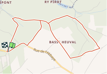
Randonnée Marche de 5,7 km à découvrir à Wallonie, Brabant wallon, Villers-la-Ville. Cette randonnée est proposée par Randos Ouvertes.
Description
Itinéraire proposé par Bernadette Stenier, membre du groupe des Randonnées Ouvertes
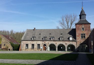
Départ Chapelle Notre Dame des Affligés
De Rue de l'Abbaye 7, 1495 Villers-la-Ville, Belgique
Localisation
Pays :
Belgique
Région :
Wallonie
Département/Province :
Brabant wallon
Commune :
Villers-la-Ville
Localité :
Villers-la-Ville
Départ:(Dec)
Départ:(UTM)
608720 ; 5605145 (31U) N.
Commentaires
Randonnées à proximité
![Randonnée Marche Villers-la-Ville - RB-Bw-10_Villers-la-Ville_via-racc-1-et-2 - Photo](https://media.geolcdn.com/t/375/260/ext.jpg?maxdim=2&url=https%3A%2F%2Fservices.sitytrail.com%2FGeolivesWS%2FDownloadMedia.ashx%3FTrailID%3D220359%26Media%3Db52f8a40-bd4e-4201-848f-58c9caafd869.jpg)
![Marche Marche](https://static1.geolcdn.com/sitytour/trail-icons/101.png)
RB-Bw-10_Villers-la-Ville_via-racc-1-et-2
Marche
Difficile
(25)
Villers-la-Ville,
Wallonie,
Brabant wallon,
Belgique
![](/images/other/stat-length.png)
13,3 km | 16,4 km-effort
3h 44min
![](https://static1.geolcdn.com/siteimages/upload/files/16400158638029165_repeat_loop_refresh_sync_direction_icon.png)
Oui
![Randonnée Marche Villers-la-Ville - RB-Bw-10_Villers-la-Ville - Photo](https://media.geolcdn.com/t/375/260/ext.jpg?maxdim=2&url=https%3A%2F%2Fservices.sitytrail.com%2FGeolivesWS%2FDownloadMedia.ashx%3FTrailID%3D220358%26Media%3Db52f8a40-bd4e-4201-848f-58c9caafd869.jpg)
![Marche Marche](https://static1.geolcdn.com/sitytour/trail-icons/101.png)
RB-Bw-10_Villers-la-Ville
Marche
Très difficile
(12)
Villers-la-Ville,
Wallonie,
Brabant wallon,
Belgique
![](/images/other/stat-length.png)
24 km | 30 km-effort
6h 43min
![](https://static1.geolcdn.com/siteimages/upload/files/16400158638029165_repeat_loop_refresh_sync_direction_icon.png)
Oui
![Randonnée Marche Genappe - RB-Bw-09_Bousval_via-racc-1-et-2 - Photo](https://media.geolcdn.com/t/375/260/ext.jpg?maxdim=2&url=https%3A%2F%2Fservices.sitytrail.com%2FGeolivesWS%2FDownloadMedia.ashx%3FTrailID%3D220340%26Media%3Dd40b4c5b-4793-41f9-ac7b-fe40a955ea25.jpg)
![Marche Marche](https://static1.geolcdn.com/sitytour/trail-icons/101.png)
RB-Bw-09_Bousval_via-racc-1-et-2
Marche
Difficile
(11)
Genappe,
Wallonie,
Brabant wallon,
Belgique
![](/images/other/stat-length.png)
9,7 km | 12,5 km-effort
2h 50min
![](https://static1.geolcdn.com/siteimages/upload/files/16400158638029165_repeat_loop_refresh_sync_direction_icon.png)
Oui
![Randonnée Marche Genappe - RB-Bw-09_Bousval-via-racc-2 - Photo](https://media.geolcdn.com/t/375/260/ext.jpg?maxdim=2&url=https%3A%2F%2Fservices.sitytrail.com%2FGeolivesWS%2FDownloadMedia.ashx%3FTrailID%3D220337%26Media%3Dcacfbcff-3084-47a0-8267-9fc97c2da542.jpg)
![Marche Marche](https://static1.geolcdn.com/sitytour/trail-icons/101.png)
RB-Bw-09_Bousval-via-racc-2
Marche
Difficile
(11)
Genappe,
Wallonie,
Brabant wallon,
Belgique
![](/images/other/stat-length.png)
13,2 km | 16,9 km-effort
3h 49min
![](https://static1.geolcdn.com/siteimages/upload/files/16400158638029165_repeat_loop_refresh_sync_direction_icon.png)
Oui
![Randonnée Marche Villers-la-Ville - RB-Bw-10_Villers-la-Ville_via-var - Photo](https://media.geolcdn.com/t/375/260/ext.jpg?maxdim=2&url=https%3A%2F%2Fservices.sitytrail.com%2FGeolivesWS%2FDownloadMedia.ashx%3FTrailID%3D179585%26Media%3Db52f8a40-bd4e-4201-848f-58c9caafd869.jpg)
![Marche Marche](https://static1.geolcdn.com/sitytour/trail-icons/101.png)
RB-Bw-10_Villers-la-Ville_via-var
Marche
Très difficile
(6)
Villers-la-Ville,
Wallonie,
Brabant wallon,
Belgique
![](/images/other/stat-length.png)
26 km | 32 km-effort
7h 15min
![](https://static1.geolcdn.com/siteimages/upload/files/16400158638029165_repeat_loop_refresh_sync_direction_icon.png)
Oui
![Randonnée Marche Genappe - RB-Bw-09_Bousval - Photo](https://media.geolcdn.com/t/375/260/ext.jpg?maxdim=2&url=https%3A%2F%2Fservices.sitytrail.com%2FGeolivesWS%2FDownloadMedia.ashx%3FTrailID%3D179584%26Media%3Dd40b4c5b-4793-41f9-ac7b-fe40a955ea25.jpg)
![Marche Marche](https://static1.geolcdn.com/sitytour/trail-icons/101.png)
RB-Bw-09_Bousval
Marche
Moyen
(9)
Genappe,
Wallonie,
Brabant wallon,
Belgique
![](/images/other/stat-length.png)
22 km | 28 km-effort
5h 59min
![](https://static1.geolcdn.com/siteimages/upload/files/16400158638029165_repeat_loop_refresh_sync_direction_icon.png)
Oui
![Randonnée Marche Genappe - Genappe - Circuit Natura 2000, des sites qui valent le détour ! - Bw03 - Photo](https://media.geolcdn.com/t/375/260/ext.jpg?maxdim=2&url=https%3A%2F%2Fservices.sitytrail.com%2FGeolivesWS%2FDownloadMedia.ashx%3FTrailID%3D356410%26Media%3D9ffde3d0-226c-45a8-b2a5-1fc6dfbe0f90.jpg)
![Marche Marche](https://static1.geolcdn.com/sitytour/trail-icons/101.png)
Genappe - Circuit Natura 2000, des sites qui valent le détour ! - Bw03
Marche
Moyen
(6)
Genappe,
Wallonie,
Brabant wallon,
Belgique
![](/images/other/stat-length.png)
7,9 km | 9,7 km-effort
2h 6min
![](https://static1.geolcdn.com/siteimages/upload/files/16400158638029165_repeat_loop_refresh_sync_direction_icon.png)
Oui
![Randonnée Marche Court-Saint-Étienne - RL-GG-22_La-Roche_Blanmont - Photo](https://media.geolcdn.com/t/375/260/ext.jpg?maxdim=2&url=https%3A%2F%2Fmedia.geolcdn.com%2Ff%2F2a6f461f-efef-416e-b536-c468aeb7dc39.jpg)
![Marche Marche](https://static1.geolcdn.com/sitytour/trail-icons/101.png)
RL-GG-22_La-Roche_Blanmont
Marche
Moyen
(2)
Court-Saint-Étienne,
Wallonie,
Brabant wallon,
Belgique
![](/images/other/stat-length.png)
21 km | 26 km-effort
5h 51min
![](https://static1.geolcdn.com/siteimages/upload/files/16400158638029165_repeat_loop_refresh_sync_direction_icon.png)
Non
![Randonnée Marche Villers-la-Ville - Balade forestière à Villers la Ville - Photo](https://media.geolcdn.com/t/375/260/ext.jpg?maxdim=2&url=https%3A%2F%2Fservices.sitytrail.com%2FGeolivesWS%2FDownloadMedia.ashx%3FTrailID%3D120927%26Media%3D124af64a-52e1-4866-a6e4-05b50b4835ef.JPG)
![Marche Marche](https://static1.geolcdn.com/sitytour/trail-icons/101.png)
Balade forestière à Villers la Ville
Marche
Facile
(5)
Villers-la-Ville,
Wallonie,
Brabant wallon,
Belgique
![](/images/other/stat-length.png)
11,5 km | 14,1 km-effort
3h 0min
![](https://static1.geolcdn.com/siteimages/upload/files/16400158638029165_repeat_loop_refresh_sync_direction_icon.png)
Oui