Randonnée Marche Camps-Saint-Mathurin-Léobazel - Le rocher du peintre - Photo
© OpenStreetMap contributors
Longueur
Longueur
9,1 km
Altitude max
Altitude max
566 m
Dénivelé positif
Dénivelé positif
154 m
Km-Effort
Km-Effort  
11,2 km
Altitude min
Altitude min
484 m
Dénivelé négatif
Dénivelé négatif
184 m
Boucle
Boucle
Non
Date de création :
2023-08-11 09:03:55.0
Dernière modification :
2023-08-11 11:17:43.928

(0 Avis)

Marche
Marche
2h02
Difficulté : Moyen

Scannez ce code QR pour ouvrir la randonnée dans l'application SityTrail

Application GPS de randonnée GRATUITE

Logo SityTrail SityTrail

IGN / Instituts géographiques

Télécharger SityTrail sur l'App Store Télécharger SityTrail sur Google Play

Logo SityTrail SityTrail World

Le monde est à vous

Télécharger SityTrail sur l'App Store Télécharger SityTrail sur Google Play Télécharger SityTrail sur Huawei AppGallery

À propos

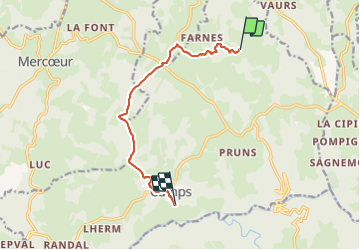
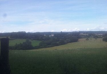
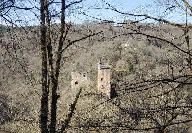
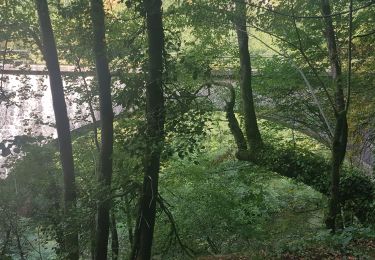
Randonnée Marche de 9,1 km à découvrir à Nouvelle-Aquitaine, Corrèze, Camps-Saint-Mathurin-Léobazel. Cette randonnée est proposée par laurentbernardbrunel.

Profil altimétrique

Photos

Localisation

Pays :
France
Région :
Nouvelle-Aquitaine
Département/Province :
Corrèze
Commune :
Camps-Saint-Mathurin-Léobazel
Localité :
Unknown
Départ:(Dec)
Départ:(UTM)
422355 ; 4985400 (31T) N.

Randonnées à proximité

Randonnée Marche Camps-Saint-Mathurin-Léobazel - Camps - Saint-Mathurin : entre terre et eaux - Photo
Marche
houbart

Marche

Difficile
(1)
Camps-Saint-Mathurin-Léobazel, Nouvelle-Aquitaine, Corrèze, France
14 km | 17,5 km-effort
3h 58min
Oui
Randonnée Marche Camps-Saint-Mathurin-Léobazel - La Via Arverna (Camps-Saint-Mathurin - Bretenoux) - Photo
Marche
tracegps

Marche

Difficile
(1)
Camps-Saint-Mathurin-Léobazel, Nouvelle-Aquitaine, Corrèze, France
29 km | 39 km-effort
8h 0min
Non
Randonnée Marche Sexcles - Le puy d'Embesse - Photo
Marche
jmarchand

Marche

Très facile
Sexcles, Nouvelle-Aquitaine, Corrèze, France
4 km | 5 km-effort
1h 29min
Non
Randonnée Marche Goulles - Les tours Carbonnieres - Photo
Marche
viam19

Marche

Difficile
Goulles, Nouvelle-Aquitaine, Corrèze, France
11,4 km | 16 km-effort
4h 20min
Oui
Randonnée Marche Camps-Saint-Mathurin-Léobazel - de Camps St Mathurin à Laval de Cere - Photo
Marche
neleda

Marche

Moyen
Camps-Saint-Mathurin-Léobazel, Nouvelle-Aquitaine, Corrèze, France
20 km | 30 km-effort
6h 37min
Non
Randonnée Marche La Chapelle-Saint-Géraud - la chappelle Saint Geraud - Photo
Marche
martinjacque

Marche

Moyen
(1)
La Chapelle-Saint-Géraud, Nouvelle-Aquitaine, Corrèze, France
5,7 km | 7,9 km-effort
1h 53min
Oui
Randonnée Cheval Camps-Saint-Mathurin-Léobazel - Lap 03 - Photo
Cheval
melifranck

Cheval

Facile
Camps-Saint-Mathurin-Léobazel, Nouvelle-Aquitaine, Corrèze, France
5,1 km | 7 km-effort
52min
Oui
Randonnée Course à pied Camps-Saint-Mathurin-Léobazel - camps_25K - Photo
Course à pied
frederic.farge

Course à pied

Moyen
Camps-Saint-Mathurin-Léobazel, Nouvelle-Aquitaine, Corrèze, France
25 km | 41 km-effort
Inconnu
Non
Randonnée Marche Camps-Saint-Mathurin-Léobazel - Lamativie-camp - Photo
Marche
albert318

Marche

Moyen
Camps-Saint-Mathurin-Léobazel, Nouvelle-Aquitaine, Corrèze, France
5 km | 8,3 km-effort
1h 7min
Non


Fermer
Mes abonnements