


Waldmatt -12/08/23 Copains w- end

chantalwaltzer
Utilisateur

Longueur
7,8 km

Altitude max
1162 m

Dénivelé positif
805 m
Km-Effort
16,1 km

Altitude min
353 m

Dénivelé négatif
64 m
Boucle
Non
Date de création :
2023-08-12 12:19:21.0
Dernière modification :
2023-08-13 07:11:15.875
4h20
Difficulté : Inconnu

Application GPS de randonnée GRATUITE
 SityTrail
IGN / Instituts géographiques
SityTrail Plus
Le monde est à vous
À propos
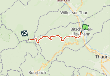
Randonnée Marche de 7,8 km à découvrir à Grand Est, Haut-Rhin, Bitschwiller-lès-Thann. Cette randonnée est proposée par chantalwaltzer.
Description
marche
Localisation
Pays :
France
Région :
Grand Est
Département/Province :
Haut-Rhin
Commune :
Bitschwiller-lès-Thann
Localité :
Unknown
Départ:(Dec)
Départ:(UTM)
356200 ; 5298923 (32T) N.
Commentaires