


rochehaut.2023 .08.15

trusgnachjf
Utilisateur
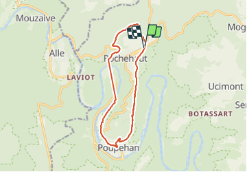

Longueur
13,1 km

Altitude max
408 m

Dénivelé positif
395 m
Km-Effort
18,4 km

Altitude min
192 m

Dénivelé négatif
395 m
Boucle
Oui
Date de création :
2023-08-15 08:53:45.793
Dernière modification :
2023-08-15 13:49:05.624
4h53
Difficulté : Difficile

Application GPS de randonnée GRATUITE
 SityTrail
IGN / Instituts géographiques
SityTrail Plus
Le monde est à vous
À propos
Randonnée Marche de 13,1 km à découvrir à Wallonie, Luxembourg, Bouillon. Cette randonnée est proposée par trusgnachjf.
Localisation
Pays :
Belgique
Région :
Wallonie
Département/Province :
Luxembourg
Commune :
Bouillon
Localité :
Unknown
Départ:(Dec)
Départ:(UTM)
644993 ; 5523263 (31U) N.
Commentaires