Randonnée Marche Baztan - De Gorramendi à Akomendi et Irubel kaskoaa - Photo

De Gorramendi à Akomendi et Irubel kaskoaa

 DECHAMPD
DECHAMPD

Utilisateur

© OpenStreetMap contributors
Longueur
Longueur
13,9 km
Altitude max
Altitude max
1083 m
Dénivelé positif
Dénivelé positif
807 m
Km-Effort
Km-Effort  
25 km
Altitude min
Altitude min
694 m
Dénivelé négatif
Dénivelé négatif
808 m
Boucle
Boucle
Oui
Date de création :
2019-01-14 17:34:41.811
Dernière modification :
2019-01-14 17:34:41.848

(0 Avis)

Marche
Marche
4h58
Difficulté : Moyen

Scannez ce code QR pour ouvrir la randonnée dans l'application SityTrail

Application GPS de randonnée GRATUITE

Logo SityTrail SityTrail

IGN / Instituts géographiques

Télécharger SityTrail sur l'App Store Télécharger SityTrail sur Google Play

Logo SityTrail SityTrail World

Le monde est à vous

Télécharger SityTrail sur l'App Store Télécharger SityTrail sur Google Play Télécharger SityTrail sur Huawei AppGallery

À propos

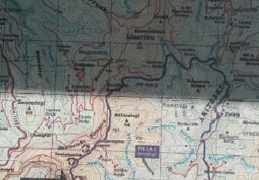
Randonnée Marche de 13,9 km à découvrir à Navarre, Inconnu, Baztan. Cette randonnée est proposée par DECHAMPD.

Description

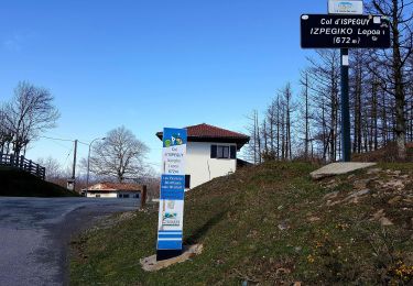
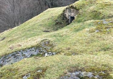
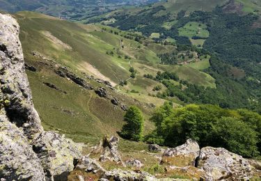
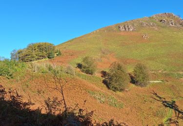
Balade hivernale et sans difficulté le long des crêtes, en "pays" de Baztan.
en direction de l'ensemble Gorramendi-Otanarte-Gorramakil, depuis le col Itzulegi / Itzulegiko lepoa. Ce massif est le premier des Pyrénées situé au-dessus de 1000m, en venant de l'Océan Atlantique.

Profil altimétrique

Points d'intérêt

Point d'intérêt Baztan - point 1 - Photo
DECHAMPD
BAZTAN 
Point d'intérêt Baztan - point 2 - Photo
DECHAMPD
BAZTAN 
Point d'intérêt Baztan - parking - Photo
DECHAMPD
BAZTAN 

Localisation

Pays :
Espagne
Région :
Navarre
Département/Province :
Inconnu
Commune :
Baztan
Localité :
Unknown
Départ:(Dec)
Départ:(UTM)
625600 ; 4786026 (30T) N.

Randonnées à proximité

Randonnée A pied Saint-Étienne-de-Baïgorry - SL-NA Elorrieta - Photo
A pied
PRO

A pied

Facile
Saint-Étienne-de-Baïgorry, Nouvelle-Aquitaine, Pyrénées-Atlantiques, France
5,8 km | 10 km-effort
2h 15min
Oui
Randonnée Marche Baztan - MAILARRETA OTSONDO Frontières en béton dans le massif du Gorramendi 300m. - Photo
Marche
DECHAMPD

Marche

Difficile
Baztan, Navarre, Inconnu, Espagne
8,5 km | 12,5 km-effort
2h 50min
Oui
Randonnée Marche Baztan - MAILARRETA OTSONDO Frontières en béton dans le massif du Gorramendi - Photo
Marche
DECHAMPD

Marche

Difficile
Baztan, Navarre, Inconnu, Espagne
10 km | 15,3 km-effort
3h 29min
Oui
Randonnée A pied Baztan - SL-NA Alkurruntz - Photo
A pied
PRO

A pied

Facile
Baztan, Navarre, Inconnu, Espagne
7 km | 11 km-effort
2h 29min
Oui
Randonnée Marche Saint-Étienne-de-Baïgorry - 20210520 tour depuis Izpegi - Photo
Marche
ThonyM

Marche

Facile
Saint-Étienne-de-Baïgorry, Nouvelle-Aquitaine, Pyrénées-Atlantiques, France
8,6 km | 14,7 km-effort
2h 59min
Oui
Randonnée Marche Baztan - ALKURRUNTZ depuis le parling de Lizarmeak - Photo
Marche
jaja64

Marche

Facile
(1)
Baztan, Navarre, Inconnu, Espagne
8,6 km | 13,8 km-effort
2h 52min
Non
Randonnée Marche Baztan - Meatzetako Bizkarra depuis le col d'Urrizti (proche d'Otsondo) - Photo
Marche
DECHAMPD

Marche

Difficile
Baztan, Navarre, Inconnu, Espagne
9,7 km | 15,2 km-effort
3h 26min
Oui
Randonnée Marche Baztan - Baztan vallée Aritzakun PR NA 6 - Photo
Marche
DECHAMPD

Marche

Moyen
(2)
Baztan, Navarre, Inconnu, Espagne
14,2 km | 22 km-effort
4h 59min
Oui
Randonnée Marche Saint-Étienne-de-Baïgorry - L
Marche
ChristopheLefauconnier

Marche

Difficile
Saint-Étienne-de-Baïgorry, Nouvelle-Aquitaine, Pyrénées-Atlantiques, France
9,8 km | 20 km-effort
3h 57min
Oui


Fermer
Mes abonnements