


26 St Vincent la commanderie Planayse village gros pi

HAL26
Utilisateur
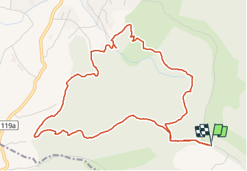

Longueur
6,5 km

Altitude max
616 m

Dénivelé positif
290 m
Km-Effort
10,3 km

Altitude min
417 m

Dénivelé négatif
290 m
Boucle
Oui
Date de création :
2023-09-14 13:34:45.15
Dernière modification :
2023-09-14 15:22:12.134
1h47
Difficulté : Facile

Application GPS de randonnée GRATUITE
 SityTrail
IGN / Instituts géographiques
SityTrail Plus
Le monde est à vous
À propos
Randonnée Marche de 6,5 km à découvrir à Auvergne-Rhône-Alpes, Drôme, Saint-Vincent-la-Commanderie. Cette randonnée est proposée par HAL26.
Localisation
Pays :
France
Région :
Auvergne-Rhône-Alpes
Département/Province :
Drôme
Commune :
Saint-Vincent-la-Commanderie
Localité :
Unknown
Départ:(Dec)
Départ:(UTM)
668443 ; 4976715 (31T) N.
Commentaires