


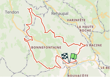
Circuit 1 le Tholy

PMarter
Utilisateur

Longueur
23 km

Altitude max
782 m

Dénivelé positif
540 m
Km-Effort
30 km

Altitude min
547 m

Dénivelé négatif
536 m
Boucle
Oui
Date de création :
2023-09-17 08:25:53.689
Dernière modification :
2023-09-17 10:44:27.877
2h16
Difficulté : Facile

Application GPS de randonnée GRATUITE
 SityTrail
IGN / Instituts géographiques
SityTrail Plus
Le monde est à vous
À propos
Randonnée V.T.T. de 23 km à découvrir à Grand Est, Vosges, Le Tholy. Cette randonnée est proposée par PMarter.
Localisation
Pays :
France
Région :
Grand Est
Département/Province :
Vosges
Commune :
Le Tholy
Localité :
Unknown
Départ:(Dec)
Départ:(UTM)
331954 ; 5327982 (32U) N.
Commentaires