Boucle hangar 9k

ophness
Utilisateur
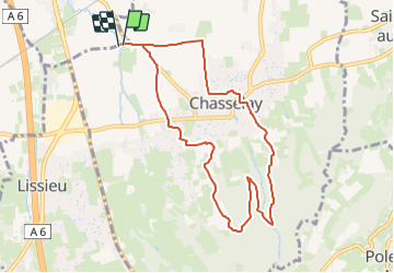

Longueur
8,8 km

Altitude max
424 m

Dénivelé positif
252 m
Km-Effort
12,1 km

Altitude min
205 m

Dénivelé négatif
254 m
Boucle
Oui
Date de création :
2023-10-21 21:27:55.0
Dernière modification :
2023-10-23 20:10:54.075
1h35
Difficulté : Facile

Application GPS de randonnée GRATUITE
 SityTrail
IGN / Instituts géographiques
SityTrail Plus
Le monde est à vous
À propos
Randonnée Randonnée équestre de 8,8 km à découvrir à Auvergne-Rhône-Alpes, Rhône, Chasselay. Cette randonnée est proposée par ophness.
Localisation
Pays :
France
Région :
Auvergne-Rhône-Alpes
Département/Province :
Rhône
Commune :
Chasselay
Localité :
Unknown
Départ:(Dec)
Départ:(UTM)
636198 ; 5082280 (31T) N.
Commentaires