


Innimond Rossillon via le Molard de Don

malc
Utilisateur
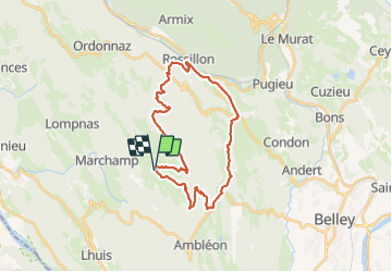

Longueur
28 km

Altitude max
1214 m

Dénivelé positif
1121 m
Km-Effort
43 km

Altitude min
327 m

Dénivelé négatif
1122 m
Boucle
Oui
Date de création :
2023-11-26 09:22:40.98
Dernière modification :
2023-11-26 11:29:08.81
2h05
Difficulté : Difficile

Application GPS de randonnée GRATUITE
 SityTrail
IGN / Instituts géographiques
SityTrail Plus
Le monde est à vous
À propos
Randonnée V.T.T. de 28 km à découvrir à Auvergne-Rhône-Alpes, Ain, Innimond. Cette randonnée est proposée par malc.
Description
descente bien engagé , fait en VTTAE
Localisation
Pays :
France
Région :
Auvergne-Rhône-Alpes
Département/Province :
Ain
Commune :
Innimond
Localité :
Unknown
Départ:(Dec)
Départ:(UTM)
700008 ; 5073078 (31T) N.
Commentaires