


Téléthon 2023

norbertmarteau
Utilisateur
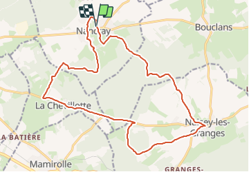

Longueur
21 km

Altitude max
492 m

Dénivelé positif
289 m
Km-Effort
25 km

Altitude min
400 m

Dénivelé négatif
285 m
Boucle
Oui
Date de création :
2023-12-08 08:30:23.428
Dernière modification :
2023-12-08 08:36:41.776
1h42
Difficulté : Moyen

Application GPS de randonnée GRATUITE
 SityTrail
IGN / Instituts géographiques
SityTrail Plus
Le monde est à vous
À propos
Randonnée V.T.T. de 21 km à découvrir à Bourgogne-Franche-Comté, Doubs, Nancray. Cette randonnée est proposée par norbertmarteau.
Description
Parcours de la rando VTT nocturne de l'édition Naisey Les Granges - Nancray du Téléthon 2023.
Photos

Localisation
Pays :
France
Région :
Bourgogne-Franche-Comté
Département/Province :
Doubs
Commune :
Nancray
Localité :
Unknown
Départ:(Dec)
Départ:(UTM)
286766 ; 5236400 (32T) N.
Commentaires