Randonnée Marche Saint-Georges-Haute-Ville - St Georges haute ville - Photo
 yvon42
yvon42

Utilisateur

© OpenStreetMap contributors
Longueur
Longueur
12,9 km
Altitude max
Altitude max
631 m
Dénivelé positif
Dénivelé positif
391 m
Km-Effort
Km-Effort  
18,1 km
Altitude min
Altitude min
418 m
Dénivelé négatif
Dénivelé négatif
390 m
Boucle
Boucle
Oui
Date de création :
2023-12-10 09:04:56.029
Dernière modification :
2023-12-10 15:20:04.241

(0 Avis)

Marche
Marche
5h46
Difficulté : Difficile

Scannez ce code QR pour ouvrir la randonnée dans l'application SityTrail

Application GPS de randonnée GRATUITE

Logo SityTrail SityTrail

IGN / Instituts géographiques

Télécharger SityTrail sur l'App Store Télécharger SityTrail sur Google Play

Logo SityTrail SityTrail World

Le monde est à vous

Télécharger SityTrail sur l'App Store Télécharger SityTrail sur Google Play Télécharger SityTrail sur Huawei AppGallery

À propos

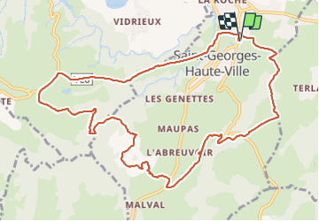
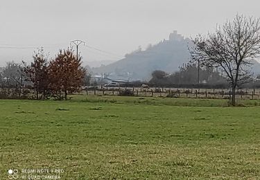
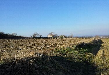
Randonnée Marche de 12,9 km à découvrir à Auvergne-Rhône-Alpes, Loire, Saint-Georges-Haute-Ville. Cette randonnée est proposée par yvon42.

Description

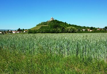
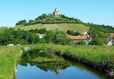
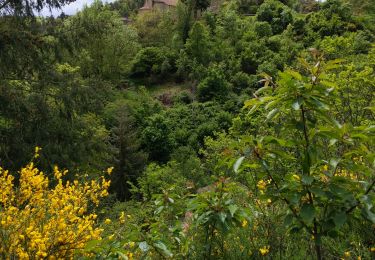
belle randonnée avec 2 montées mais,de beaux paysages

Profil altimétrique

Localisation

Pays :
France
Région :
Auvergne-Rhône-Alpes
Département/Province :
Loire
Commune :
Saint-Georges-Haute-Ville
Localité :
Unknown
Départ:(UTM)
585808 ; 5045134 (31T) N.

Randonnées à proximité

Randonnée Marche Lavieu - Lavieu D 101 parking  - Photo
Marche
Migrounet42

Marche

Très difficile
Lavieu, Auvergne-Rhône-Alpes, Loire, France
14 km | 19,7 km-effort
5h 19min
Oui
Randonnée V.T.T. Montbrison - Forez1 - Photo
V.T.T.
ramsay

V.T.T.

Moyen
(1)
Montbrison, Auvergne-Rhône-Alpes, Loire, France
31 km | 40 km-effort
2h 35min
Oui
Randonnée V.T.T. Saint-Romain-le-Puy - Tous à Vélo à Saint-Romain (petit circuit) - Saint Romain le Puy - Photo
V.T.T.
tracegps

V.T.T.

Moyen
Saint-Romain-le-Puy, Auvergne-Rhône-Alpes, Loire, France
18,5 km | 21 km-effort
1h 40min
Oui
Randonnée V.T.T. Saint-Romain-le-Puy - Tous à Vélo à Saint-Romain (grand circuit) - Saint Romain le Puy - Photo
V.T.T.
tracegps

V.T.T.

Difficile
Saint-Romain-le-Puy, Auvergne-Rhône-Alpes, Loire, France
23 km | 30 km-effort
2h 40min
Oui
Randonnée V.T.T. Montbrison - Virade de l'espoir - Moingt - Photo
V.T.T.
tracegps

V.T.T.

Très difficile
Montbrison, Auvergne-Rhône-Alpes, Loire, France
21 km | 28 km-effort
2h 0min
Oui
Randonnée Marche Saint-Romain-le-Puy - precieux - Photo
Marche
jepea

Marche

Très facile
Saint-Romain-le-Puy, Auvergne-Rhône-Alpes, Loire, France
6,1 km | 6,5 km-effort
1h 40min
Oui
Randonnée Marche Montbrison - boucle de Bard - Photo
Marche
dudu42

Marche

Moyen
Montbrison, Auvergne-Rhône-Alpes, Loire, France
15 km | 20 km-effort
4h 1min
Oui
Randonnée Autre activité Lézigneux - 2012-03-01 16h53m07 - Photo
Autre activité
bclement

Autre activité

Très facile
Lézigneux, Auvergne-Rhône-Alpes, Loire, France
7,2 km | 10 km-effort
1h 44min
Oui
Randonnée Marche Montbrison - StJ-J8-Montbrison-Marols - Photo
Marche
Bonsaicd

Marche

Très difficile
Montbrison, Auvergne-Rhône-Alpes, Loire, France
19,7 km | 28 km-effort
6h 4min
Non


Fermer
Mes abonnements