


Tour du brand avec point de vue

OxygenLT
Utilisateur
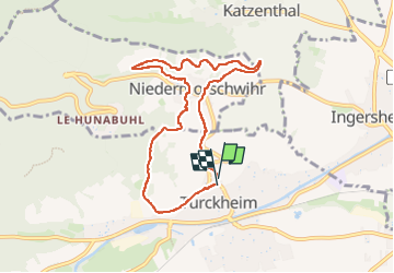

Longueur
7,6 km

Altitude max
379 m

Dénivelé positif
227 m
Km-Effort
10,7 km

Altitude min
246 m

Dénivelé négatif
239 m
Boucle
Oui
Date de création :
2024-02-29 16:00:53.478
Dernière modification :
2024-05-16 09:54:34.335
1h40
Difficulté : Facile

Application GPS de randonnée GRATUITE
 SityTrail
IGN / Instituts géographiques
SityTrail Plus
Le monde est à vous
À propos
Randonnée Marche de 7,6 km à découvrir à Grand Est, Haut-Rhin, Turckheim. Cette randonnée est proposée par OxygenLT.
Localisation
Pays :
France
Région :
Grand Est
Département/Province :
Haut-Rhin
Commune :
Turckheim
Localité :
Unknown
Départ:(Dec)
Départ:(UTM)
371769 ; 5327777 (32U) N.
Commentaires