Randonnée Marche Baztan - Baztan 009 Gorramendi Itzlegi pays Baztan - Photo

Baztan 009 Gorramendi Itzlegi pays Baztan

 DECHAMPD
DECHAMPD

Utilisateur

© OpenStreetMap contributors
Longueur
Longueur
12,6 km
Altitude max
Altitude max
1083 m
Dénivelé positif
Dénivelé positif
550 m
Km-Effort
Km-Effort  
19,9 km
Altitude min
Altitude min
697 m
Dénivelé négatif
Dénivelé négatif
543 m
Boucle
Boucle
Oui
Date de création :
2019-01-14 17:34:38.31
Dernière modification :
2019-01-14 17:34:38.388

(0 Avis)

Marche
Marche
4h08
Difficulté : Moyen

Scannez ce code QR pour ouvrir la randonnée dans l'application SityTrail

Application GPS de randonnée GRATUITE

Logo SityTrail SityTrail

IGN / Instituts géographiques

Télécharger SityTrail sur l'App Store Télécharger SityTrail sur Google Play

Logo SityTrail SityTrail World

Le monde est à vous

Télécharger SityTrail sur l'App Store Télécharger SityTrail sur Google Play Télécharger SityTrail sur Huawei AppGallery

À propos

Randonnée Marche de 12,6 km à découvrir à Navarre, Inconnu, Baztan. Cette randonnée est proposée par DECHAMPD.

Description

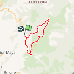
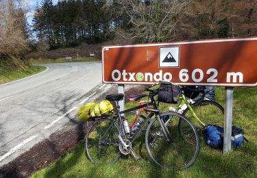
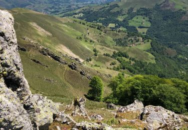
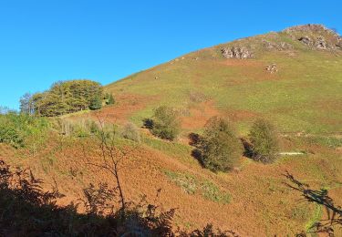
Balade hivernale et sans difficulté le long des crêtes, en "pays" de Baztan.
en direction de l'ensemble Gorramendi-Otanarte-Gorramakil, depuis le col Itzulegi. Ce massif est le premier des Pyrénées situé au-dessus de 1000m, en venant de l'Océan Atlantique.

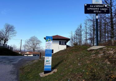
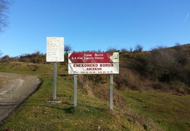
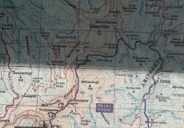
Depuis le col Itzulegi 700m, table d'orientation Alto Aizpitza 961m, Maistrugain (cromlechs), Gorramendi 1070m, Otanarte gaine 1071m, Gorramakil 1087m, l'Alkaplanta (falaises), col Burdingutzeta 895m, et retour par Uniz 752m, Olaintzin, Urtsuko borda 822m.

Profil altimétrique

Localisation

Pays :
Espagne
Région :
Navarre
Département/Province :
Inconnu
Commune :
Baztan
Localité :
Unknown
Départ:(Dec)
Départ:(UTM)
625590 ; 4786085 (30T) N.

Commentaires

Veuillez vous connecter pour laisser un commentaire ou une note


Très bien


Randonnées à proximité

Randonnée A pied Saint-Étienne-de-Baïgorry - SL-NA Elorrieta - Photo
A pied
PRO

A pied

Facile
Saint-Étienne-de-Baïgorry, Nouvelle-Aquitaine, Pyrénées-Atlantiques, France
5,8 km | 10 km-effort
2h 15min
Oui
Randonnée Marche Baztan - MAILARRETA OTSONDO Frontières en béton dans le massif du Gorramendi 300m. - Photo
Marche
DECHAMPD

Marche

Difficile
Baztan, Navarre, Inconnu, Espagne
8,5 km | 12,5 km-effort
2h 50min
Oui
Randonnée Marche Baztan - MAILARRETA OTSONDO Frontières en béton dans le massif du Gorramendi - Photo
Marche
DECHAMPD

Marche

Difficile
Baztan, Navarre, Inconnu, Espagne
10 km | 15,3 km-effort
3h 29min
Oui
Randonnée A pied Baztan - SL-NA Alkurruntz - Photo
A pied
PRO

A pied

Facile
Baztan, Navarre, Inconnu, Espagne
7 km | 11 km-effort
2h 29min
Oui
Randonnée Marche Saint-Étienne-de-Baïgorry - 20210520 tour depuis Izpegi - Photo
Marche
ThonyM

Marche

Facile
Saint-Étienne-de-Baïgorry, Nouvelle-Aquitaine, Pyrénées-Atlantiques, France
8,6 km | 14,7 km-effort
2h 59min
Oui
Randonnée Marche Baztan - ALKURRUNTZ depuis le parling de Lizarmeak - Photo
Marche
jaja64

Marche

Facile
(1)
Baztan, Navarre, Inconnu, Espagne
8,6 km | 13,8 km-effort
2h 52min
Non
Randonnée Marche Baztan - Meatzetako Bizkarra depuis le col d'Urrizti (proche d'Otsondo) - Photo
Marche
DECHAMPD

Marche

Difficile
Baztan, Navarre, Inconnu, Espagne
9,7 km | 15,2 km-effort
3h 26min
Oui
Randonnée Marche Baztan - Baztan vallée Aritzakun PR NA 6 - Photo
Marche
DECHAMPD

Marche

Moyen
(2)
Baztan, Navarre, Inconnu, Espagne
14,2 km | 22 km-effort
4h 59min
Oui
Randonnée Marche Saint-Étienne-de-Baïgorry - L
Marche
ChristopheLefauconnier

Marche

Difficile
Saint-Étienne-de-Baïgorry, Nouvelle-Aquitaine, Pyrénées-Atlantiques, France
9,8 km | 20 km-effort
3h 57min
Oui


Fermer
Mes abonnements