Randonnée Marche Nancy - Nancy (Meurthe-Canal) 10 710m +68m - Photo

Nancy (Meurthe-Canal) 10 710m +68m

 DanielROLLET
DanielROLLET

Utilisateur

© OpenStreetMap contributors
Longueur
Longueur
10,7 km
Altitude max
Altitude max
202 m
Dénivelé positif
Dénivelé positif
68 m
Km-Effort
Km-Effort  
11,6 km
Altitude min
Altitude min
184 m
Dénivelé négatif
Dénivelé négatif
68 m
Boucle
Boucle
Oui
Date de création :
2024-03-07 07:52:52.671
Dernière modification :
2024-03-11 14:21:16.455

(0 Avis)

Marche
Marche
2h40
Difficulté : Facile

Scannez ce code QR pour ouvrir la randonnée dans l'application SityTrail

Application GPS de randonnée GRATUITE

Logo SityTrail SityTrail

IGN / Instituts géographiques

Télécharger SityTrail sur l'App Store Télécharger SityTrail sur Google Play

Logo SityTrail SityTrail World

Le monde est à vous

Télécharger SityTrail sur l'App Store Télécharger SityTrail sur Google Play Télécharger SityTrail sur Huawei AppGallery

À propos

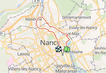
Randonnée Marche de 10,7 km à découvrir à Grand Est, Meurthe-et-Moselle, Nancy. Cette randonnée est proposée par DanielROLLET.

Description

2024 03 07 - Rando ATC - 5 participants
Grand beau temps mais frais
8h55 à 11h 35
Eviter rive droite de la Meurthe entre Pont de Vayringes et viaduc Louis Marin (coulées boueuses du mur de soutènement)

Profil altimétrique

Localisation

Pays :
France
Région :
Grand Est
Département/Province :
Meurthe-et-Moselle
Commune :
Nancy
Localité :
Unknown
Départ:(UTM)
293776 ; 5396043 (32U) N.

Randonnées à proximité

Randonnée Course à pied Pulnoy - Parcours de santé PULNOY - Photo
Course à pied
DENOMME

Course à pied

Très facile
(1)
Pulnoy, Grand Est, Meurthe-et-Moselle, France
4,8 km | 6 km-effort
58min
Oui
Randonnée A pied Champigneulles - Circuit du Val Saint-Barthélémy - Photo
A pied
PRO

A pied

Facile
Champigneulles, Grand Est, Meurthe-et-Moselle, France
7 km | 8,6 km-effort
1h 57min
Oui
Randonnée A pied Agincourt - Circuit M - Photo
A pied
PRO

A pied

Facile
Agincourt, Grand Est, Meurthe-et-Moselle, France
13,3 km | 17,8 km-effort
4h 3min
Non
Randonnée Marche Nancy - Ma dernière avant opération  - Photo
Marche
Toyot 8

Marche

Très difficile
(1)
Nancy, Grand Est, Meurthe-et-Moselle, France
22 km | 25 km-effort
4h 12min
Oui
Randonnée Marche Vandœuvre-lès-Nancy - Randonnée USEP 2023 - Photo
Marche
nicolas54230

Marche

Difficile
(1)
Vandœuvre-lès-Nancy, Grand Est, Meurthe-et-Moselle, France
11,7 km | 15,2 km-effort
3h 27min
Non
Randonnée Marche Nancy - Ma rando du jour - Photo
Marche
Toyot 8

Marche

Difficile
Nancy, Grand Est, Meurthe-et-Moselle, France
35 km | 41 km-effort
5h 55min
Oui
Randonnée Marche Nancy - Nancy Gondreville Nancy - Photo
Marche
Toyot 8

Marche

Difficile
Nancy, Grand Est, Meurthe-et-Moselle, France
64 km | 74 km-effort
10h 57min
Oui
Randonnée Marche Nancy - Nancy Saizeray Jaillon Pierre la Treiche Marion Nancy  - Photo
Marche
Toyot 8

Marche

Difficile
Nancy, Grand Est, Meurthe-et-Moselle, France
73 km | 85 km-effort
12h 13min
Oui
Randonnée A pied Villers-lès-Nancy - Promenade d'Hardeval - Photo
A pied
PRO

A pied

Facile
Villers-lès-Nancy, Grand Est, Meurthe-et-Moselle, France
3,2 km | 4,3 km-effort
58min
Oui


Fermer
Mes abonnements