Randonnée Marche Saint-Alban-Leysse - monterminod-15-03-2024 - Photo
 papou73
papou73

Utilisateur

© OpenStreetMap contributors
Longueur
Longueur
5,5 km
Altitude max
Altitude max
594 m
Dénivelé positif
Dénivelé positif
295 m
Km-Effort
Km-Effort  
9,5 km
Altitude min
Altitude min
298 m
Dénivelé négatif
Dénivelé négatif
297 m
Boucle
Boucle
Oui
Date de création :
2024-03-11 12:10:58.634
Dernière modification :
2024-03-11 16:14:10.513

(0 Avis)

Marche
Marche
2h09
Difficulté : Moyen

Scannez ce code QR pour ouvrir la randonnée dans l'application SityTrail

Application GPS de randonnée GRATUITE

Logo SityTrail SityTrail

IGN / Instituts géographiques

Télécharger SityTrail sur l'App Store Télécharger SityTrail sur Google Play

Logo SityTrail SityTrail World

Le monde est à vous

Télécharger SityTrail sur l'App Store Télécharger SityTrail sur Google Play Télécharger SityTrail sur Huawei AppGallery

À propos

Randonnée Marche de 5,5 km à découvrir à Auvergne-Rhône-Alpes, Savoie, Saint-Alban-Leysse. Cette randonnée est proposée par papou73.

Profil altimétrique

Photos

Localisation

Pays :
France
Région :
Auvergne-Rhône-Alpes
Département/Province :
Savoie
Commune :
Saint-Alban-Leysse
Localité :
Unknown
Départ:(UTM)
730701 ; 5051762 (31T) N.

Randonnées à proximité

Randonnée Course à pied Saint-Jean-d'Arvey - Tour du plateau de la Leysse - Photo
Course à pied
pzellner

Course à pied

Très facile
(1)
Saint-Jean-d'Arvey, Auvergne-Rhône-Alpes, Savoie, France
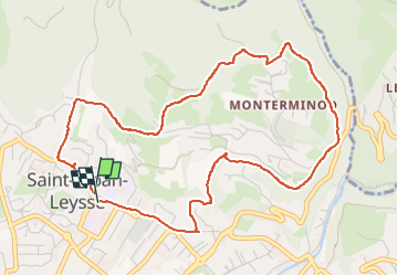
47 km | 82 km-effort
10h 0min
Oui
Randonnée Marche Challes-les-Eaux - Le Mont Saint-Michel 895 m, depuis Challes-les-Eaux - Photo
Marche
tracegps

Marche

Difficile
(1)
Challes-les-Eaux, Auvergne-Rhône-Alpes, Savoie, France
7,6 km | 15 km-effort
4h 15min
Oui
Randonnée V.T.T. Bassens - Pragondra - Photo
V.T.T.
Gorki

V.T.T.

Très facile
(1)
Bassens, Auvergne-Rhône-Alpes, Savoie, France
24 km | 34 km-effort
2h 49min
Non
Randonnée V.T.T. Cognin - Autour du Corbeley - Photo
V.T.T.
baudrine

V.T.T.

Moyen
(1)
Cognin, Auvergne-Rhône-Alpes, Savoie, France
25 km | 38 km-effort
2h 23min
Oui
Randonnée Vélo Saint-Jean-d'Arvey - st jean meythet via plainpalais et semnoz - Photo
Vélo
jojoimothep

Vélo

Difficile
(1)
Saint-Jean-d'Arvey, Auvergne-Rhône-Alpes, Savoie, France
66 km | 92 km-effort
3h 16min
Non
Randonnée Marche Saint-Alban-Leysse - 73- Le chemin des poussettes - Photo
Marche
cavpsy74

Marche

Facile
(1)
Saint-Alban-Leysse, Auvergne-Rhône-Alpes, Savoie, France
4,9 km | 10,6 km-effort
2h 2min
Oui
Randonnée V.T.T. Saint-Alban-Leysse - 2012-03-24 - Malpassant+ St sat - Photo
V.T.T.
maxx73

V.T.T.

Moyen
(1)
Saint-Alban-Leysse, Auvergne-Rhône-Alpes, Savoie, France
27 km | 44 km-effort
3h 2min
Oui
Randonnée Marche Curienne - Boucle de curienne  - Photo
Marche
choubaka77

Marche

Facile
Curienne, Auvergne-Rhône-Alpes, Savoie, France
6,2 km | 9,1 km-effort
2h 22min
Oui
Randonnée Marche Les Déserts - Nivolet - Photo
Marche
cousam

Marche

Moyen
Les Déserts, Auvergne-Rhône-Alpes, Savoie, France
8,5 km | 19 km-effort
5h 29min
Oui


Fermer
Mes abonnements