Randonnée  Saint-Restitut - St Restitut, Chabrieres, le Barry - Photo

St Restitut, Chabrieres, le Barry

 alinetpierre
alinetpierre

Utilisateur

© OpenStreetMap contributors
Longueur
Longueur
15,2 km
Altitude max
Altitude max
283 m
Dénivelé positif
Dénivelé positif
429 m
Km-Effort
Km-Effort  
21 km
Altitude min
Altitude min
134 m
Dénivelé négatif
Dénivelé négatif
428 m
Boucle
Boucle
Oui
Date de création :
2024-03-20 08:24:56.0
Dernière modification :
2024-03-20 15:11:46.407

(0 Avis)


Scannez ce code QR pour ouvrir la randonnée dans l'application SityTrail

Application GPS de randonnée GRATUITE

Logo SityTrail SityTrail

IGN / Instituts géographiques

Télécharger SityTrail sur l'App Store Télécharger SityTrail sur Google Play

Logo SityTrail SityTrail World

Le monde est à vous

Télécharger SityTrail sur l'App Store Télécharger SityTrail sur Google Play Télécharger SityTrail sur Huawei AppGallery

À propos

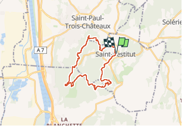
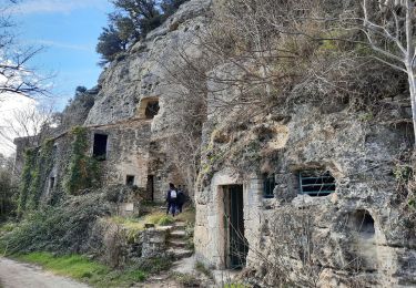
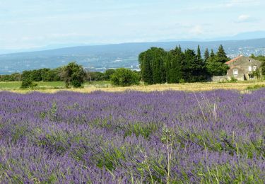
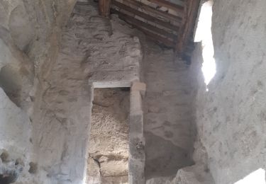
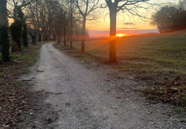
Randonnée de 15,2 km à découvrir à Auvergne-Rhône-Alpes, Drôme, Saint-Restitut. Cette randonnée est proposée par alinetpierre.

Description

Boucle autour de St Restitut, azur

Profil altimétrique

Photos

Localisation

Pays :
France
Région :
Auvergne-Rhône-Alpes
Département/Province :
Drôme
Commune :
Saint-Restitut
Localité :
Unknown
Départ:(Dec)
Départ:(UTM)
642732 ; 4910290 (31T) N.

Randonnées à proximité

Randonnée Marche Bollène - Barry Chabrières Enclume 7,5km - Photo
Marche
GUIDE
thonyc

Marche

Moyen
(1)
Bollène, Provence-Alpes-Côte d'Azur, Vaucluse, France
7,6 km | 10,1 km-effort
2h 30min
Oui
Randonnée Marche Saint-Restitut - St Restitut Barry 14km - Photo
Marche
GUIDE
thonyc

Marche

Moyen
(1)
Saint-Restitut, Auvergne-Rhône-Alpes, Drôme, France
13,7 km | 18,1 km-effort
5h 0min
Oui
Randonnée Marche Saint-Restitut - St Restitut Le Barry 12km - Photo
Marche
chancha

Marche

Moyen
(1)
Saint-Restitut, Auvergne-Rhône-Alpes, Drôme, France
12,2 km | 15,9 km-effort
3h 37min
Oui
Randonnée Marche Saint-Restitut - Les carrières de Sainte Juste - Saint Restitut - Photo
Marche
tracegps

Marche

Moyen
(2)
Saint-Restitut, Auvergne-Rhône-Alpes, Drôme, France
12,8 km | 16,8 km-effort
3h 30min
Oui
Randonnée Marche Suze-la-Rousse - soleirieu - Photo
Marche
losjo

Marche

Facile
(1)
Suze-la-Rousse, Auvergne-Rhône-Alpes, Drôme, France
11,9 km | 14,7 km-effort
3h 8min
Oui
Randonnée Marche Clansayes - Clansayes Le Rouvergue 12km - Photo
Marche
GUIDE
thonyc

Marche

Facile
Clansayes, Auvergne-Rhône-Alpes, Drôme, France
12,4 km | 15,8 km-effort
3h 0min
Oui
Randonnée V.T.T. Saint-Paul-Trois-Châteaux - VTT_13R_Le Val des Nymphes - Photo
V.T.T.
charlytan

V.T.T.

Difficile
(1)
Saint-Paul-Trois-Châteaux, Auvergne-Rhône-Alpes, Drôme, France
33 km | 39 km-effort
2h 42min
Oui
Randonnée Marche Saint-Restitut - st restitut moi - Photo
Marche
toinou30

Marche

Moyen
Saint-Restitut, Auvergne-Rhône-Alpes, Drôme, France
17,4 km | 24 km-effort
5h 57min
Oui
Randonnée Marche Bollène - Chabrieres  - Photo
Marche
Perdrizet Pascal

Marche

Moyen
Bollène, Provence-Alpes-Côte d'Azur, Vaucluse, France
5,2 km | 8,2 km-effort
2h 0min
Oui


Fermer
Mes abonnements