Randonnée Cheval Villapourçon - Etoile Cussy - Photo
 zachval
zachval

Utilisateur

© OpenStreetMap contributors
Longueur
Longueur
31 km
Altitude max
Altitude max
700 m
Dénivelé positif
Dénivelé positif
978 m
Km-Effort
Km-Effort  
44 km
Altitude min
Altitude min
324 m
Dénivelé négatif
Dénivelé négatif
960 m
Boucle
Boucle
Oui
Date de création :
2024-03-27 20:33:12.396
Dernière modification :
2024-03-27 20:34:10.153

(0 Avis)

Cheval
Cheval
0m
Difficulté : Très facile

Scannez ce code QR pour ouvrir la randonnée dans l'application SityTrail

Application GPS de randonnée GRATUITE

Logo SityTrail SityTrail

IGN / Instituts géographiques

Télécharger SityTrail sur l'App Store Télécharger SityTrail sur Google Play

Logo SityTrail SityTrail World

Le monde est à vous

Télécharger SityTrail sur l'App Store Télécharger SityTrail sur Google Play Télécharger SityTrail sur Huawei AppGallery

À propos

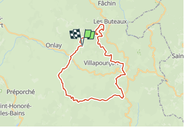
Randonnée Cheval de 31 km à découvrir à Bourgogne-Franche-Comté, Nièvre, Villapourçon. Cette randonnée est proposée par zachval.

Profil altimétrique

Localisation

Pays :
France
Région :
Bourgogne-Franche-Comté
Département/Province :
Nièvre
Commune :
Villapourçon
Localité :
Unknown
Départ:(UTM)
571155 ; 5201634 (31T) N.

Randonnées à proximité

Randonnée Marche Villapourçon - w-frankrijk-bron-van-de-yonne - Photo
Marche
gpstracks

Marche

Très facile
(1)
Villapourçon, Bourgogne-Franche-Comté, Nièvre, France
7,2 km | 10,3 km-effort
Inconnu
Oui
Randonnée Marche Villapourçon - Villapourçon - Photo
Marche
Ennis

Marche

Difficile
Villapourçon, Bourgogne-Franche-Comté, Nièvre, France
11,8 km | 16,9 km-effort
3h 25min
Oui
Randonnée Marche Onlay - Tour du Morvan pédestre - de Onlay à Larochemillay  - Photo
Marche
tracegps

Marche

Moyen
Onlay, Bourgogne-Franche-Comté, Nièvre, France
22 km | 31 km-effort
4h 45min
Non
Randonnée Randonnée à dos d'âne Villapourçon - cascade dragne - Photo
Randonnée à dos d'âne
bub27

Randonnée à dos d'âne

Facile
Villapourçon, Bourgogne-Franche-Comté, Nièvre, France
5,2 km | 7,2 km-effort
2h 0min
Oui
Randonnée sport Villapourçon - Sommant cussy V3 - Photo
sport
Berthonneau

sport

Très facile
Villapourçon, Bourgogne-Franche-Comté, Nièvre, France
37 km | 51 km-effort
Inconnu
Non
Randonnée sport Villapourçon - Etoile 2 Cussy - Photo
sport
Berthonneau

sport

Très facile
Villapourçon, Bourgogne-Franche-Comté, Nièvre, France
27 km | 39 km-effort
Inconnu
Oui
Randonnée Marche Villapourçon - Nièvre villapourçon - Photo
Marche
yuggse

Marche

Moyen
Villapourçon, Bourgogne-Franche-Comté, Nièvre, France
7,3 km | 10,3 km-effort
2h 20min
Oui
Randonnée Marche Villapourçon - 20220527 Mont Beuvray en partant de Villapourçon - Photo
Marche
marieamelie

Marche

Difficile
Villapourçon, Bourgogne-Franche-Comté, Nièvre, France
12,2 km | 20 km-effort
3h 35min
Non
Randonnée Marche Villapourçon - Tour du Morvan 12 Villapourçon - Larochemillay - Photo
Marche
Tournan

Marche

Difficile
Villapourçon, Bourgogne-Franche-Comté, Nièvre, France
13,2 km | 19,2 km-effort
3h 57min
Non


Fermer
Mes abonnements