Randonnée V.T.T. Ladinhac - rando vtt tremouille 2024 - Photo

rando vtt tremouille 2024

 kayakiste15
kayakiste15

Utilisateur

© OpenStreetMap contributors
Longueur
Longueur
33 km
Altitude max
Altitude max
797 m
Dénivelé positif
Dénivelé positif
789 m
Km-Effort
Km-Effort  
43 km
Altitude min
Altitude min
575 m
Dénivelé négatif
Dénivelé négatif
790 m
Boucle
Boucle
Oui
Date de création :
2024-03-31 07:14:45.824
Dernière modification :
2024-03-31 09:44:51.005

(0 Avis)

V.T.T.
V.T.T.
2h25
Difficulté : Moyen

Scannez ce code QR pour ouvrir la randonnée dans l'application SityTrail

Application GPS de randonnée GRATUITE

Logo SityTrail SityTrail

IGN / Instituts géographiques

Télécharger SityTrail sur l'App Store Télécharger SityTrail sur Google Play

Logo SityTrail SityTrail World

Le monde est à vous

Télécharger SityTrail sur l'App Store Télécharger SityTrail sur Google Play Télécharger SityTrail sur Huawei AppGallery

À propos

Randonnée V.T.T. de 33 km à découvrir à Auvergne-Rhône-Alpes, Cantal, Ladinhac. Cette randonnée est proposée par kayakiste15.

Description

rando tremouille 2024

Profil altimétrique

Localisation

Pays :
France
Région :
Auvergne-Rhône-Alpes
Département/Province :
Cantal
Commune :
Ladinhac
Localité :
Unknown
Départ:(UTM)
460350 ; 4958255 (31T) N.

Randonnées à proximité

Randonnée V.T.T. Murols - Le batut 1 - Photo
V.T.T.
Patrick Garcia

V.T.T.

Moyen
Murols, Occitanie, Aveyron, France
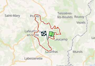
19,1 km | 30 km-effort
3h 18min
Oui
Randonnée Marche Lafeuillade-en-Vézie - lafeuillade en vezie  - Photo
Marche
nikouston15

Marche

Très facile
Lafeuillade-en-Vézie, Auvergne-Rhône-Alpes, Cantal, France
7,7 km | 10,3 km-effort
1h 36min
Oui
Randonnée Marche Sansac-Veinazès - Rando à Sansac Veinazés - Photo
Marche
tracegps

Marche

Moyen
Sansac-Veinazès, Auvergne-Rhône-Alpes, Cantal, France
8 km | 10,9 km-effort
2h 0min
Oui
Randonnée Randonnée équestre Teissières-lès-Bouliès - Boucle teissieres les bouiles - Photo
Randonnée équestre
AdeBoyer

Randonnée équestre

Très facile
Teissières-lès-Bouliès, Auvergne-Rhône-Alpes, Cantal, France
11,6 km | 14,9 km-effort
2h 48min
Oui
Randonnée Marche Ladinhac - tremouille  - Photo
Marche
nikouston15

Marche

Facile
Ladinhac, Auvergne-Rhône-Alpes, Cantal, France
6,4 km | 8,8 km-effort
1h 55min
Oui
Randonnée Marche Labesserette - rando chausy - Photo
Marche
Clément Sorin

Marche

Difficile
Labesserette, Auvergne-Rhône-Alpes, Cantal, France
15,5 km | 22 km-effort
3h 56min
Oui
Randonnée Marche Lafeuillade-en-Vézie - Lafeuillade - Photo
Marche
Midego

Marche

Moyen
Lafeuillade-en-Vézie, Auvergne-Rhône-Alpes, Cantal, France
7,9 km | 10,5 km-effort
2h 23min
Oui
Randonnée Marche Leucamp - Leucamp pays du granit  - Photo
Marche
alainlissac

Marche

Facile
Leucamp, Auvergne-Rhône-Alpes, Cantal, France
7,9 km | 10,1 km-effort
1h 55min
Oui
Randonnée Marche Lafeuillade-en-Vézie - Lafeuillade laça pelle moulin  - Photo
Marche
alainlissac

Marche

Facile
Lafeuillade-en-Vézie, Auvergne-Rhône-Alpes, Cantal, France
7,7 km | 10,2 km-effort
1h 57min
Oui


Fermer
Mes abonnements