Randonnée Marche Luxembourg - Itinérant Luxembourg Jour 1 : Visite de Luxembourg Ville - Photo

Itinérant Luxembourg Jour 1 : Visite de Luxembourg Ville

 chessyca
chessyca

Utilisateur

© OpenStreetMap contributors
Longueur
Longueur
15,6 km
Altitude max
Altitude max
327 m
Dénivelé positif
Dénivelé positif
437 m
Km-Effort
Km-Effort  
21 km
Altitude min
Altitude min
239 m
Dénivelé négatif
Dénivelé négatif
432 m
Boucle
Boucle
Oui
Date de création :
2024-04-02 10:33:30.403
Dernière modification :
2024-04-10 21:24:31.296

(0 Avis)

Marche
Marche
3h45
Difficulté : Facile

Scannez ce code QR pour ouvrir la randonnée dans l'application SityTrail

Application GPS de randonnée GRATUITE

Logo SityTrail SityTrail

IGN / Instituts géographiques

Télécharger SityTrail sur l'App Store Télécharger SityTrail sur Google Play

Logo SityTrail SityTrail World

Le monde est à vous

Télécharger SityTrail sur l'App Store Télécharger SityTrail sur Google Play Télécharger SityTrail sur Huawei AppGallery

À propos

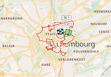
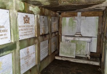
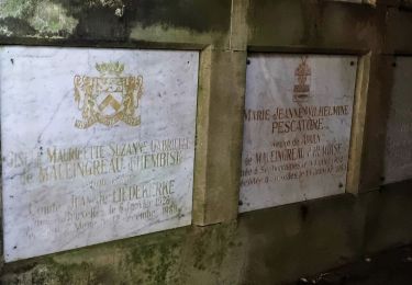
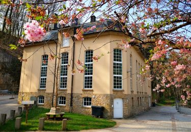
Randonnée Marche de 15,6 km à découvrir à Inconnu, Canton Luxembourg, Luxembourg. Cette randonnée est proposée par chessyca.

Description

Découverte ou redécouverte des principaux lieux touristiques de la ville
Petit tour en Tram et funiculaire (retirer environ 3 km du trajet vers le quartier europe)
Hébergement hotel de jeunesse Luxembourg Ville

Profil altimétrique

Photos

Localisation

Pays :
Luxembourg
Région :
Inconnu
Département/Province :
Canton Luxembourg
Commune :
Luxembourg
Localité :
Pfaffenthal
Départ:(UTM)
293253 ; 5499536 (32U) N.

Randonnées à proximité

Randonnée A pied Luxembourg - Promenade érable - Photo
A pied
PRO

A pied

Facile
Luxembourg, Inconnu, Canton Luxembourg, Luxembourg
4,7 km | 6 km-effort
1h 21min
Oui
Randonnée A pied Walferdange - Auto-Pédestre Bereldange - Photo
A pied
PRO

A pied

Facile
Walferdange, Inconnu, Canton Luxembourg, Luxembourg
6,5 km | 9 km-effort
2h 2min
Oui
Randonnée A pied Leudelange - Auto-Pédestre Roedgen - Photo
A pied
PRO

A pied

Facile
Leudelange, Inconnu, Canton Esch-sur-Alzette, Luxembourg
9,7 km | 11,9 km-effort
2h 42min
Oui
Randonnée A pied Luxembourg - Sentier pédestre Hibou - Photo
A pied
PRO

A pied

Facile
Luxembourg, Inconnu, Canton Luxembourg, Luxembourg
7,7 km | 9,9 km-effort
2h 14min
Oui
Randonnée A pied Luxembourg - Parcours de cross - Photo
A pied
PRO

A pied

Facile
Luxembourg, Inconnu, Canton Luxembourg, Luxembourg
4,9 km | 6,3 km-effort
1h 26min
Oui
Randonnée Marche Hesperange - Autopedestres : Hesperange - Photo
Marche
GUIDE+

Marche

Très facile
(1)
Hesperange, Inconnu, Canton Luxembourg, Luxembourg
4,9 km | 6,2 km-effort
Inconnu
Oui
Randonnée Marche nordique Bertrange - Bertrange - Marche nordique - Photo
Marche nordique
collignpn

Marche nordique

Très facile
Bertrange, Inconnu, Canton Luxembourg, Luxembourg
15,9 km | 18,1 km-effort
Inconnu
Non
Randonnée A pied Hesperange - Sentier Naturel autour de Dupont - Photo
A pied
PRO

A pied

Facile
Hesperange, Inconnu, Canton Luxembourg, Luxembourg
4 km | 4,9 km-effort
1h 6min
Oui
Randonnée A pied Hesperange - Fleche Bleu Itzig - Photo
A pied
PRO

A pied

Facile
Hesperange, Inconnu, Canton Luxembourg, Luxembourg
8,3 km | 10,7 km-effort
2h 26min
Oui


Fermer
Mes abonnements