


20240409 Champhol

Jeanclaudebic
Utilisateur
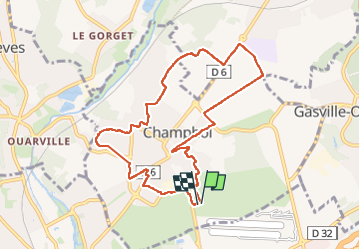

Longueur
8,7 km

Altitude max
157 m

Dénivelé positif
42 m
Km-Effort
9,3 km

Altitude min
146 m

Dénivelé négatif
41 m
Boucle
Oui
Date de création :
2024-04-09 11:52:47.661
Dernière modification :
2024-04-09 14:15:02.831
2h12
Difficulté : Moyen

Application GPS de randonnée GRATUITE
 SityTrail
IGN / Instituts géographiques
SityTrail Plus
Le monde est à vous
À propos
Randonnée Marche de 8,7 km à découvrir à Centre-Val de Loire, Eure-et-Loir, Champhol. Cette randonnée est proposée par Jeanclaudebic.
Localisation
Pays :
France
Région :
Centre-Val de Loire
Département/Province :
Eure-et-Loir
Commune :
Champhol
Localité :
Unknown
Départ:(Dec)
Départ:(UTM)
390014 ; 5368548 (31U) N.
Commentaires