Randonnée Marche Champ-Laurent - batteries m'ont gilbert - Photo
 lionelnottat
lionelnottat

Utilisateur

© OpenStreetMap contributors
Longueur
Longueur
16 km
Altitude max
Altitude max
1468 m
Dénivelé positif
Dénivelé positif
642 m
Km-Effort
Km-Effort  
25 km
Altitude min
Altitude min
1123 m
Dénivelé négatif
Dénivelé négatif
641 m
Boucle
Boucle
Oui
Date de création :
2024-04-16 07:07:11.69
Dernière modification :
2024-04-16 14:02:00.82

(0 Avis)

Marche
Marche
4h51
Difficulté : Très difficile

Scannez ce code QR pour ouvrir la randonnée dans l'application SityTrail

Application GPS de randonnée GRATUITE

Logo SityTrail SityTrail

IGN / Instituts géographiques

Télécharger SityTrail sur l'App Store Télécharger SityTrail sur Google Play

Logo SityTrail SityTrail World

Le monde est à vous

Télécharger SityTrail sur l'App Store Télécharger SityTrail sur Google Play Télécharger SityTrail sur Huawei AppGallery

À propos

Randonnée Marche de 16 km à découvrir à Auvergne-Rhône-Alpes, Savoie, Champ-Laurent. Cette randonnée est proposée par lionelnottat.

Profil altimétrique

Localisation

Pays :
France
Région :
Auvergne-Rhône-Alpes
Département/Province :
Savoie
Commune :
Champ-Laurent
Localité :
Unknown
Départ:(UTM)
282850 ; 5042897 (32T) N.

Randonnées à proximité

Randonnée Marche Montgilbert - les batteries par Montgilbert  - Photo
Marche
jibebouvier

Marche

Facile
Montgilbert, Auvergne-Rhône-Alpes, Savoie, France
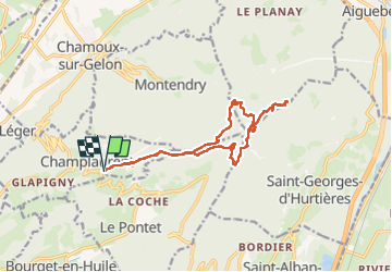
11,5 km | 19,5 km-effort
3h 10min
Oui
Randonnée Marche Montgilbert - source des 7 fontaines - Photo
Marche
jibebouvier

Marche

Très facile
Montgilbert, Auvergne-Rhône-Alpes, Savoie, France
13,5 km | 19 km-effort
1h 47min
Non
Randonnée Marche Saint-Alban-d'Hurtières - col du GD cucheron / les granges - Photo
Marche
laurentnecca

Marche

Moyen
Saint-Alban-d'Hurtières, Auvergne-Rhône-Alpes, Savoie, France
13,4 km | 20 km-effort
5h 15min
Non
Randonnée Marche Saint-Alban-d'Hurtières - gd Cucheron col du Champet - Photo
Marche
Frufin

Marche

Très difficile
Saint-Alban-d'Hurtières, Auvergne-Rhône-Alpes, Savoie, France
11 km | 19,8 km-effort
4h 30min
Oui
Randonnée Marche Saint-Alban-d'Hurtières - grand Cucheron Ft Mont Gilbert  - Photo
Marche
Frufin

Marche

Difficile
Saint-Alban-d'Hurtières, Auvergne-Rhône-Alpes, Savoie, France
10,2 km | 16,6 km-effort
3h 46min
Oui
Randonnée Randonnée équestre Villard-Léger - 2305 BoucleCoise  - Photo
Randonnée équestre
xhakon

Randonnée équestre

Moyen
Villard-Léger, Auvergne-Rhône-Alpes, Savoie, France
33 km | 45 km-effort
6h 30min
Oui
Randonnée Randonnée équestre Châteauneuf - 23004 BoucleCoise PrintempsCheval - Photo
Randonnée équestre
xhakon

Randonnée équestre

Moyen
Châteauneuf, Auvergne-Rhône-Alpes, Savoie, France
23 km | 31 km-effort
4h 30min
Oui
Randonnée Marche Hauteville - hauteville - Photo
Marche
Bugeat

Marche

Très difficile
Hauteville, Auvergne-Rhône-Alpes, Savoie, France
18,5 km | 28 km-effort
5h 4min
Oui
Randonnée Randonnée équestre Villard-Léger - 2303 boucle Bourgneuf Betonnnet - Photo
Randonnée équestre
xhakon

Randonnée équestre

Moyen
Villard-Léger, Auvergne-Rhône-Alpes, Savoie, France
25 km | 29 km-effort
4h 30min
Non


Fermer
Mes abonnements