


Lissieu - Azergue - Bas de Theizé Chateau Machy > Ste Paule

aeldin
Utilisateur
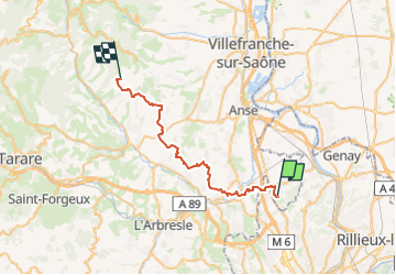

Longueur
33 km

Altitude max
539 m

Dénivelé positif
1002 m
Km-Effort
45 km

Altitude min
190 m

Dénivelé négatif
767 m
Boucle
Non
Date de création :
2024-04-18 16:13:34.623
Dernière modification :
2024-04-18 17:45:22.461
5h56
Difficulté : Très difficile

Application GPS de randonnée GRATUITE
 SityTrail
IGN / Instituts géographiques
SityTrail Plus
Le monde est à vous
À propos
Randonnée Randonnée équestre de 33 km à découvrir à Auvergne-Rhône-Alpes, Rhône, Chasselay. Cette randonnée est proposée par aeldin.
Localisation
Pays :
France
Région :
Auvergne-Rhône-Alpes
Département/Province :
Rhône
Commune :
Chasselay
Localité :
Unknown
Départ:(Dec)
Départ:(UTM)
636591 ; 5080242 (31T) N.
Commentaires