


rando Bucey 16 mai 2024

evelyne10
Utilisateur
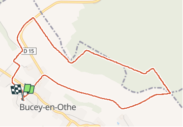

Longueur
5,9 km

Altitude max
240 m

Dénivelé positif
117 m
Km-Effort
7,4 km

Altitude min
141 m

Dénivelé négatif
117 m
Boucle
Oui
Date de création :
2024-05-16 11:59:21.652
Dernière modification :
2024-05-16 13:43:35.065
1h43
Difficulté : Facile

Application GPS de randonnée GRATUITE
 SityTrail
IGN / Instituts géographiques
SityTrail Plus
Le monde est à vous
À propos
Randonnée Marche de 5,9 km à découvrir à Grand Est, Aube, Bucey-en-Othe. Cette randonnée est proposée par evelyne10.
Photos


Localisation
Pays :
France
Région :
Grand Est
Département/Province :
Aube
Commune :
Bucey-en-Othe
Localité :
Unknown
Départ:(Dec)
Départ:(UTM)
563819 ; 5345552 (31U) N.
Commentaires